
No Regrets Despite All the Wind and Rain-An Interview with Typhoon Hunter Chun-chieh Wu

Summer, a season of wind and rain, is the busiest time in a year for typhoon hunters.
Scorching sun bakes the sea water, from which wind gets energy and increases its convection, which in turn brings up the wind speed again and then the cycle of stronger and stronger momentum and convection. Finally, an intense counterclockwise cyclone – typhoon – takes shape, and is shunned by all aircraft except one jet plane flying from Ching- Chuang-Kang Airport in Taichung right into it.
Deep into the Red Zone
This typhoon-chasing jet always takes off at 5 a.m. or returns at 11 p.m. in the danger of thunderstokes, hailstones, or emergency landings at nearby airports in storm. Inside the plane are a group of typhoon hunters probing the cyclone deep into the red zone. How do they handle every jolty flight and their fear and their family's worries?
“Frankly, I got used to all this long time ago. I started doing it since I was still in school. … If there is any stress, it's from the responsibility to meet the public expectation of accurate weather forecasts,” answered Chun-chieh Wu, the most senior chaser of typhoons in Taiwan.
Having flown through the eye of a typhoon near Mexican coast back in 1991, Wu now chairs NTU's Department of Atmospheric Sciences and directs the DOTSTAR project codeveloped by National Science Council and Central Weather Bureau (CWB). Since 2003, he has started flying with his team over to about 13 km above any typhoon potentially affecting Taiwan to conduct a close watch. This August CWB was under public attack with its misjudgment on the calamitous Typhoon Morakot while Wu's team was also falsely criticized by misleading news stories.
Some media arbitrarily created the term “seemingly strong typhoon” and quoted it under the name of the DOTSTAR to make a lurid title. Under huge pressure, Wu set straight the record with a brief notice and just shrugged it off as a minor misunderstanding. But he felt sorry for the ensuing early retirement of De-rong Wu, director of the Weather Forecast Center, and the scapegoat role forced upon CWB when Nature hit hard.
Reasons for Inaccurate Forecasts
Wu explained that lack of accuracy in forecasts results from the limit of science. A forecast is calculated by dynamics formulas with data observed from the atmosphere and the sea. A limited budget forbids boundless comprehensive data gathering, especially that at sea. Besides, computers simulate the typhoon by making numerous grids for the atmosphere, which may not perfectly represent real scenarios. And to provide timely forecasts, the mathematical tools and formulas must not be too complicated and the size of each grid is also restrained. While the dynamics formulas are highly sensitive to the initial data, minor errors will grow large after repeated calculation. Given the extreme complexity of atmosphere and lack of knowledge in certain physical processes of it, scientific errors in weather forecasts are inevitable.
In predicting the track of typhoon, for example, the worldwide average error of forecast 24 hours ahead the landfall is about 100 km, which equals to a difference of several cities/counties but is still considered scientifically tolerable. That's also why some cities would have a placid typhoon break while others would have a stormy workday. And 100 km is just the average; as a 50-km error means “lucky,” an “unlucky” forecast could misjudge the track by 150 km.
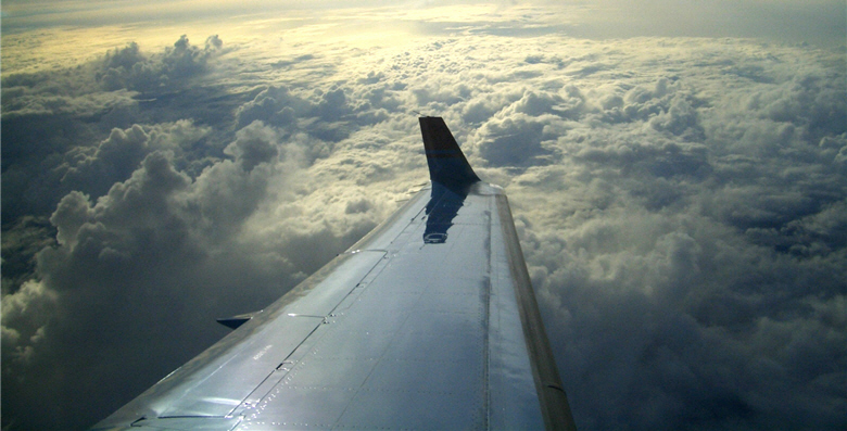
- upper: They took a plane flied to the sky, figured out the best way to forecast typhoon news for people/ by jack8
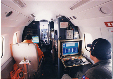
- lower left: The jet plane rented by the DOTSTAR from Aerospace Industrial evelopment Corporation (AIDC). The picture shows the inside of the remodeled cabin.
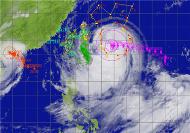
- lower right: The DOTSTAR team took a flight to observe the track of Typhoon Morakot.
Interview & Text/ Joyce Chang
Translator/ Kuan-yu Oui
Photo provided by/ Chun-chieh Wu
Rain Falls Where Typhoon Goes?
Even tougher is to predict precipitation, the ultimate challenge in weather forecasting. The way CWB revised its forecasts seven times on potential rainfall brought by Morakot was gravely criticized. In fact, precipitation forecasts are subject to change based on the latest data, and Taiwan has been one of the few countries that dare to offer predictions on rainfall, whose worldwide average accuracy is only 0.2 to 0.3. (Calculated by the formula C/(A+B - C).A means rainfall in predicted area A; B means rainfall in actual area B; C means rainfall in the overlap of areas A & B.)
Elements affecting rainfall are so complex that even the same tracks of typhoons may come with different types and locations of rainfall as landforms and peripheral atmospheric conditions may play a role. Typhoons Herb and Toraji were the type that rain fell where they went, while for Kalmaegi and Morakot the rain fell in southern Taiwan as they headed north, with downpour mainly on central Taiwan metropolises and central/southern mountain areas respectively.
The atmosphere is a chaotic system hard to predict through formulas. That's why natural disasters happen. In Taiwan, the annual average loss caused by typhoons is over NT$17 billion. Just as buying insurance relieves the loss brought by accidents, Wu believed, investing in the perfection of forecasting would reduce the damage of natural disasters and gain remarkable payback.
In Taiwan, the economic output affected by a one-day typhoon break is near NT$10 billion while in the U.S., every one mile (about 1.6 km) by which a forecast reduces its error in predicting hurricane tracks would lower the cost in evacuating the red-alert areas by US$1 million.
How difficult is it to reduce the error by 1.6 km? Over the past 30-plus years, weather forecasters have used radars, satellites, airborne observations, etc. to compute atmospheric data collected and assimilated into the computerized model to reduce the error of 24-hour-ahead track forecasts from 300 km in the 1970s to 100 km nowadays, which means a 2% improvement every year in a period of more than 30 years. Even with this rate, space for future error reduction is becoming limited.
This limitation, however, is evidently contradictory to the public expectation. With record-setting climatic abnormalities continuing to threaten people's lives and properties, the public request on weather forecasts becomes ever simpler: zero error, a goal that, Wu said, the DOTSTAR project would keep striving for by focusing on “strategic observations.”
Targeted Observations on Sensitive Areas
Strategic observations are also called targeted observations, which act like targeted therapy in medical treatment against cancer that do not kill whatever kinds of cells as traditional chemotherapy does. Targeted observations work in the same way.
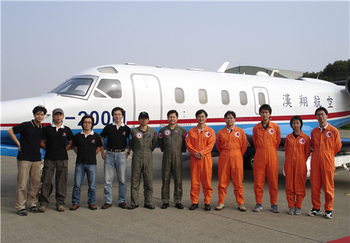
- upper left: The DOTSTAR team (dressed in orange) posed for a photograph with AIDC aircraft staff.
- upper right: The DOTSTAR team had obtained the data of wind directions and wind peeds in various pressure levels of Typhoon Morakot.
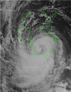
- lower: The DOTSTAR team circles the rim of the typhoon in chase of it. ncounters with turbulence, thunderstrokes and hailstones are common.
Typhoons affecting Taiwan are formed mostly on the ocean, where data observed is rare. The DOTSTAR would send its plane to sea surface, circling a typhoon and dropping the dropwindsonde, a weather reconnaissance device, into it to collect data, which would be transmitted back to CWB for computing. What matters is not the number of dropwindsondes but the location at which they are thrown into a typhoon. Finding “sensitive areas” becomes the key to an economical and effective targeted observation. Wu's team has found that typhoons move along the edge of a Pacific high, which indicates a sensitive area.
Sensitive areas feature greater air current changes, but they are right where the typhoon hunters head into aboard a jet whenever a threatening typhoon takes shape. Wu said that in the U.S. this task is taken by full-time professional researchers and technicians, while in Taiwan it is hard to ask meteorologist civil servants to brave such danger, so the duty has fallen upon the academia.
Why is the academic community willing to take such great risk? In addition to pursuing scientific advancement, it's because if their studies may reduce the error in track forecasts by just dozens of kilometers, considerable amounts of money and numerous families will be well saved.
The DOTSTAR project
The project of Dropwindsonde Observation for Typhoon Surveillance near the TAiwan Region (DOTSTAR) employs jet plane rides to the skirts of typhoons and releases dropwindsondes at an altitude of 13 km while conducting observations for 5 to 6 hours each flight to collect atmospheric data , including temperature, humidity, air pressure, wind speed, etc., in key areas at the rims of typhoons. The data will be transmitted in real time to the computers of CWB in Taiwan and of weather agencies around the world to facilitate the prediction of the tracks and peripheral structures of typhoons.
From Typhoon Dujuan in 2003 to Morakot and Parma in 2009, the DOTSTAR has completed 42 surveillance flight missions for 34 typhoons. As of the end of 2004, the data collected by dropwindsondes may help the U.S. Weather Bureau, U.S. Navy and Japan Meteorological Agency improve the accuracy of typhoon track forecasts 24 to 72 hours ahead of landfall by up to 20%.
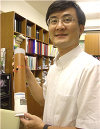
Profile of Prof. Chun-chieh Wu
Distinguished Professor and Chairman of the Department of Atmospheric Sciences, National Taiwan University, and Director of the DOTSTAR project (Dropwindsonde Observation for Typhoon Surveillance near the TAiwan Region). Major research areas include typhoon dynamics, targeted observations, and numerical modeling and data assimilation of typhoons. More details about DOTSTAR are posted on the project's website at:
http://typhoon.as.ntu.edu.tw/DOTSTAR/tw/intro/intro.php
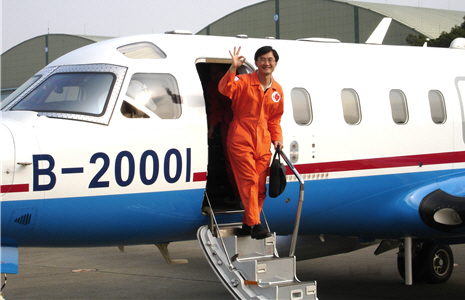
- upper left: Chun-chieh Wu was walking out of the cabin after a flight mission. Due to the air traffic control, the DOTSTAR jet always takes off at dawn or returns at midnight. The trips to and from Taichung considered, the DOTSTAR team always leaves home and returns in the dark.
- upper right: DOTSTAR stands for Dropwindsonde Observation for Typhoon Surveillance near the TAiwan Region.


