
Lessons Learned from the Record-breaking Flood-Reflecting on Weather Abnormalities and Debris Flow Prevention
On the coast of Wan-li-tong, the ebb reveals the coral reef that spreads all over the place. The reef best describes the feelings of travelers journeying in a foreign land. Wan-litong, which situates within Kenting National Park (KNP), is where a lead character in the movie Cape No.7,went for seaviewing.
A Heartbreaking Father's Day
On August 8th, 2009, Typhoon Morakot wreaked catastrophic damage in central and southern Taiwan, leaving 758 people dead and missing, resulting in NT$16.4 billion in damages, and forcing over 24,500 people to evacuate. The catastrophe reminiscent of the scene in the movie The Day After Tomorrow shows the destructive power of natural disasters. However, also within the influence of the outer band of the typhoon, KNP didn't suffer from major damages. Thanks to efforts on natural landscape conservation there, the unique, precious and fragile landscape and ecosystem were restored.
A subtropical island, Taiwan is frequented by typhoons from May through Oct., which cause great loss of life and properties. Professor Ben Jong-Dao Jou of the Department of Atmospheric Science of NTU, said that factors influencing the path of a typhoon are complex and difficult to predict. However, understanding various aspects of typhoons and making accurate use of weather forecasts may minimize possible damages.
Unpredictable Tracks of Typhoons
The track of a typhoon is influenced by the atmospheric environment, the steering flow, , the sea surface temperature, Earth rotation, and other typhoons nearby (the Fujiwhara effect). The steering flow is a major influence over the typhoon, which moves rapidly (or slowly) when dragged by a rapid (or slow) air flow. Just like a vortex moves with water currents, the passage of a typhoon is determined by the steering flow, but it's more complex and unpredictable than the case of a vortex.
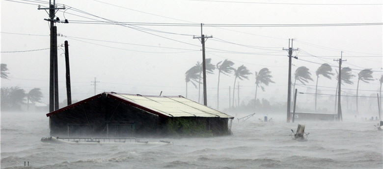
- upper: The downpour brought by the typhoon Morakot brought serius trail to South Taiwan./by Xue-sheng Liu
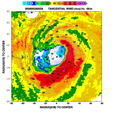
- lower left: The Doppler radar observations of Typhoon Jangmi in 2008. The white and blue area represents the eye of the typhoon and the dark magenta area represents areas with torrential rain. The distribution of rainfall brought by Typhoon Jangmi is highly asymmetric. The black lines represent the swirling intensity of the typhoon. / Photo provided by Professor Jong-dao Jou.
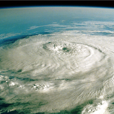
- lower right: Perfect storms created by extreme weather patterns have become a big concern for countries around the world. / Photo provided by Photos.com
Interview & Text/ Jane Chiu
Special thanks to/ Professor Ben Jong-Dao Jou of the Department of Atmospheric Science of NTU,
Professor Jiun-Chuan Lin of the Department of Geology, NTU
Translator/ Teresa Huang
Typhoons often move from the east of the Philippines towards the northwest or west-northwest but rarely southeastwards or southwestwards because to the north of the typhoon is a vast Pacific anticyclone that rotates clockwise. Influenced by it, typhoons move westwards accordingly.
A typhoon takes shape in tropical sea surface where water temperature reaches over 26.5 ℃ , a condition that the east of the Philippines meets year-round. When atmospheric disturbances cause low atmospheric pressure, large body of sea water'll vaporize and rise up to form a tropical depression, and the air nearby flows in and then rises up again. The cycle sends the air flow into a constant rotation and extension and a typhoon might developed as a result.
As the Earth rotates rapidly from the west to the east, it produces the Coriolis force, a deflection of the moving air. This force is zero at the equator, and becomes greater at higher latitude. This variation makes typhoons hardly originate near the equator and causes them to tend to move northwards when they travel westwards.
When two typhoons 1000-1500 kms away from each other draw closer, the two vortices will be attracted to each other. This phenomenon is known as the Fujiwhara effect. Jou noted that such effect usually takes place in Northwest Pacific because there tends to be two or more typhoons active concurrently in this broad sea area, thus increasing the likelihood of the Fujiwhara effect.
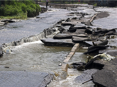
- upper left: Tungmao River, a confluent of the Tachia River, was affected by debris flows.
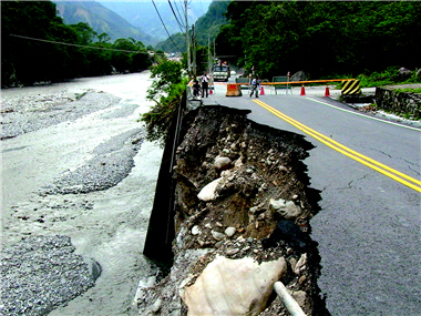
- upper right: Lateral erosion of the Tachia River has broken off the roads.
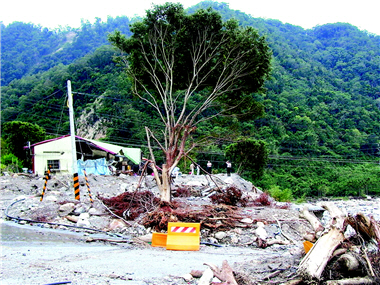
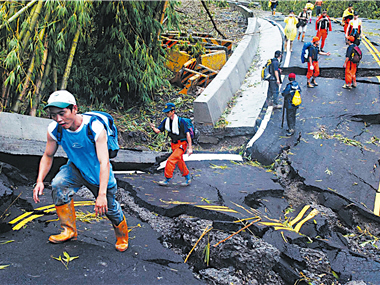
- lower left: The severest flood in a hundred years was a lesson learned the hard way. Many infrastructure people take pride in turned out to be a burden for Nature. / by Adu.
- lower right: The typhoon Morakot of Torrential rain collapsed the road. Photo was rescue team to get into Xiao lin village by walkng. /by Gao Binyuan
The current intensity classification of typhoons adopted in Taiwan is in pursuant to the one employed to categorize wind force by the UN World Meteorological Organization (WMO). It makes sense because typhoons make impact mainly by storm surges caused by strong wind. But in the case of Morakot, Jou reminded, the devastation caused was not by the strong wind but by the southwesterly airflow which brought heavy rains. In the future, whether the classification of typhoons should take rainfall into account worths discussion.
Integrate Information System and Improve
Rainfall Forecast How may rainfall be accurately predicted so as to minimize the impact of a typhoon? Due to Taiwan's highly complex geographical environment, it's hard to forecast the precipitation of sudden torrential rains. For instance, a rainfall over 2,000 millimeters was truly difficult to estimate in advance of the landfall of Morakot.
Jou said that forecasts on rainfall and related disasters require the integration of disaster prevention information from relevant bodies such as rainfall forecasts from CWB, rainfall estimates and forecasts for the watersheds of the Water Resources Agency, and the Warning System of the Debris Flow by the Soil and Water Conservation Bureau. With such information at hand, disaster rescue can be carried out more smoothly and effectively.
Typhoons occurring between summer and autumn are particularly destructive because the accompanying strong southwesterly flow brings heavy rain, as in the case of Typhoon Herb (1996), Mindulle (2004), Haitang (2005) and Morakot (2009). Jou warns that people should be vigilant and stay on high alert to minimize the loss of life and property.

Profile of Professor Jiun-Chuan Lin
A Ph.D. in Geography at London University, U.K, Professor Lin had directed the Department of Geography, NTU, from 2000 to 2006 and he is now a full professor at the department. He specializes in changes in the landscape, erosions, landscape conservation, etc. He took part in research projects funded by the NSC, projects commissioned by the CEPD, and Human Resource Development Plan commissioned by the MOE.

Profile of Professor Jong-dao Jou
A Ph.D. in Atmospheric Science at Washington University, U.S. A, Professor Jou is currently teaching at the Department of Atmospheric Science of NTU. He specializes in Mesoscale Meteorology, weather dynamics and Doppler Radar Analysis. He had chaired various research projects, including one funded by the National Science Council, one commissioned by the Taipei City Government, and another experiment carried out with scientists elsewhere on southwesterly airflow.


