
Precious Gifts Hidden Underneath-Mineral Recources in National Parks
Taiwan charmed navigators by its beauty and was hailed Formosa during the Age of Discovery from the 15th to 17th century. The explorers then found and acclaimed Taiwan a treasure island rich in mineral resources. After conquering Taiwan by military forces, excited great powers were eager to exploit mineral resources around the island: coal and sulfur in the North,salt and phosphate in the South, and gold and marble in the East.
The 1950s saw the heyday of mineral exploitation when Taiwan's economy took off. The society prospered ,regrettably ,at the expense of environmental degradation. Fortunately,impacted by the global trend of natural conservation and sustainable development, Taiwan established several national parks in the 1980s and thus protected many critical mineral veins. It is the duty of all people in Taiwan to preserve and pass them down to future generations.
Sulfur at Yangmingshan National Park (YMSNP)
YMSNP has been renowned for its volcanic landforms, hosting volcanic craters, sulfur vents, hydrothermal vents, and hot springs. Rich and versatile mineral resources lie underneath volcanic rocks. It is notably the only natural sulfur reservoir in Taiwan. "Beitou was once home to Taiwan's largest ceramic factories. One of their sources of raw materials was Yangmingshan, which also partly supplied materials for the glass-making industry in Hsinchu," says Li-chang Lu, Chief of Yangmingshuwu Service Station, who has been investigating the mining history of Yangmingshan for two decades. "Fishermen's Trail was actually developed to mine and transport sulfur in the early days."
The Qing government realized that Taipei Basin was abundant in sulfur, which bore great military importance. So in 1696, Yonghe Yu was sent to Taiwan for sulfur mining. During Qianlong Emperor's reign, the government organized troops from the mainland every three months to seal Mt. Datun from illegal civilian miners. Sulfur vents were blockaded and Miscanthus weeds burned to prevent illegal miners from hiding. The troops' bases can still be seen today along Fishermen's Trail.
While Lengshuikeng contained Taiwan's only precipitated sulfur reserve, Dayoukeng had the island's biggest sublimed sulfur deposit, accompanied by giant sulfur vents that often blasted huge amount of sulfur gases and made the vents barely reachable. To extract sulfur, condensers were installed around the vents, producing sulfur at 99.5% purity. Sihuangziping was the largest sulfur production site in Taiwan, rendering an average of 200 to 300 tons of top quality sulfur per month.
U.S. and Japanese sulfur began to dominate global markets and flood into Taiwan after the end of WWII. Taiwan's sulfur miners closed down as local mining costs hovered and local sulfur paled imported products in quality. In the 1980s, recycled elemental sulfur, a byproduct of oil refining, quickly replaced natural sulfur. Thus, sulfur in Yangmingshan lost its economic value yet was able to be preserved.
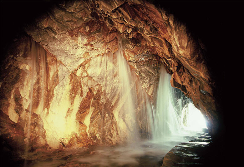
- upper:The rock ceiling of the Water Curtain, a famous tourist attraction at Taroko National Park, contains crystal limestone ores./ by Wei-yu Ke
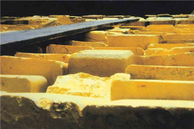
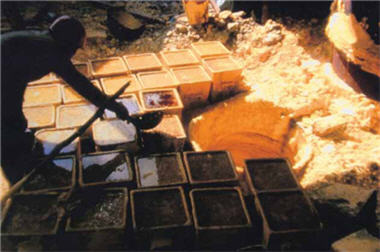
- lower left、lower right:The process of sulfur mining at Dayoukeng in YMSNP back in the era of mining industry. The picture on the left shows a sulfur factory./Provided by YMSNP Headquarters
Interview & Text / Hsiu-mei Li
Translator/ Stephen Liu
Special Thanks to / Contract Interpreter Mr. Mao-yao Lin of TNP
Headquarters、Section Chief Mr. Shun-fa Chang, Chief
Mr. Li-chang Lu, and Technical Specialist Ms. Shu-chun Yu of YMSNP Headquarters、
Technical Specialist Ms. Zhen-yu Chen of YSNP Headquarters、Technical
Specialist Ms. Le-jia Shang of MNP Headquarters
Stone Mines at Taroko National Park (TNP)
Taiwan's gold mine spread across Central Mountains and the area from Jiufen to Jinguashi. According to the Bureau of Mine, MOEA, quartz veins containing gold are found on Mt. Nanhu, Mt. Jhongyangjian, Mt. Hehuan, Mt. Pingfeng, Mt. Nenggao, and Mt. Jade; sand gold riverbeds are found in Liwu River, Hualien River, Siouguluan River, and Bainan River. Gold was found downstream of Liwu River when the Portuguese got to eastern Taiwan in the early 16th century. They named the river Rio Duero, or the Golden River, after the Portugal golden mine.
Japanese occupants constructed Batongguan Traversing Trail partly for mining purposes. Japanese probing tunnels
could be seen nearby Walami, where gold and copper concentrated. From 1939 to 1941, the colonial government hired a thousand workers to explore, and found sand gold in 38 rivers spanning from Central Mountains. The governmentthen allowed the public to apply for panning for gold, but the project was suspended as the Pacific War broke out.
The Veterans Affairs Commission took over the right for mining at the estuary of Liwu River. Yet the cost of mining remained high due to the steep Central Mountains, transportation difficulties, and frequent natural disasters. Mining stopped in 1991 when most high-concentration golden veins had been included in national parks. Since then, Central Mountains had become a legendary gold treasure range for long.
With unfulfilled gold prospects, the mining industry turned to target stones from the 1960s onward. Located on the east of Central Mountains, Taroko had the most ancient geology and was rich in stone resources, especially for marble and dolomite. With low hardness and durability and high vulnerability to long-time acid rain, marble was gradually substituted by imported granite, and marble quarries began to close down from the 1980s. Marblemining within Taroko National Park has been prohibited since before 2000.
Granite at Kinmen National Park (KMNP)
Kinmen's geology is primarily composed by igneous and sedimentary rocks. The former include granite and lamprophyre. Laid on top of igneous rocks, sedimentary rocks are mainly quartz sand, clay, and laterite gravel. That is why Kinmen is famous for its granite and ceramic industries.
Granite, widely distributed in Kinmen island, has long been the major construction material used by local residents. Granite fills people's life in all sorts of buildings, such as houses, road pavements, religious sculptures, towers, monuments, and wartime bunkers, military forts, and even hospitals. Mineral stones and rocks have definitely been an integral part of Kinmen architecture and culture.
Due to the lucrative potential of granite, Kinmen Granite Quarry was founded in August, 1971, followed by operations in Liaoluo, Yangming, Xiaxing and Tianpu. But since the 1990s, they had been closing due to environmental changes, rising conservationism, foreign competitions, as well as the establishment of KMNP.
Kinmen has been known for its military importance for decades, but the granite-based buildings across the islet is another equally distinctive feature and historical heritage that is worth exploring for tourists.
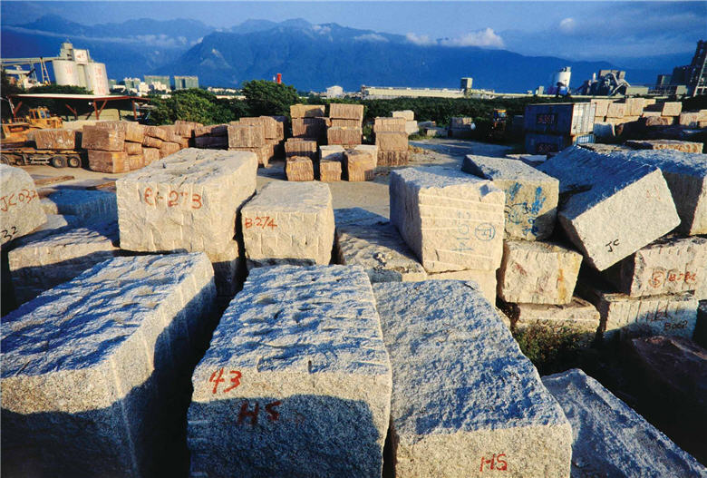
- upper:Granite has been a major construction material in Kinmen./ by Jin-yuan Dai
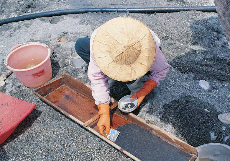
- lower:With time changing and the limits on environment imposed, gold-panning has become a demonstration activity for tourists in modern-day Taiwan./ by Mao-yao Lin
Phosphate at Dongsha Atoll National Park
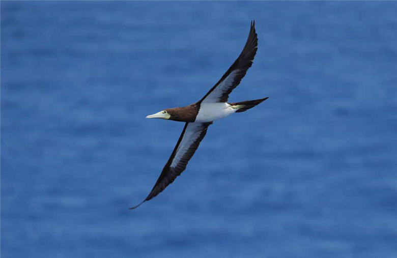
Phosphate resources on Dongsha Island were recorded in the early Qing Dynasty with the cause of formation unknown. In 1866, British Naturalist Cuthbert Collingwood landed on the island for one day in a ship accident. In his record Collingwood described hundreds of Brown Boobies (Sula leucogaster) building nests and rearing baby birds on the island. Brown Boobies ate fish in the sea yet could not digest the phosphate in the fish, and thus excreted it on land as guano manure, which formed a reservoir of phosphate over time.
In 1901, a Japanese named Nishizawa Yoshizi was drifted to Dongsha Island on a ship. He collected guano manure, brought back to Taiwan for testing, and confirmed its economic value for large-scale exploitation. In 1907, he recruited 200 people to the island, tore down existing buildings, built infrastructure, and even issued special Nishizawa banknotes. Although the Qing court finally ended his illegitimate occupation, the damage to the resources had been made.
Phosphate on Dongsha was nearly depleted from the 19th to early 20th century when the Qing and ROC government granted private mining of phosphate. After the 2nd Sino-Japanese War broke out in 1937, the Japanese seized Dongsha and turned it into a military base; thus, the remaining phosphate was finally emptied.
Dongsha Island is administered by Cijin District, Kaohsiung City. The establishment of Dongsha Atoll National Park in 2007 was a symbolic leap towards environmental conservation. Though to restore a primitive Dongsha may be a distant dream, we are sure to see a more diversified and versatile ecosystem on the island.
Salt at Taijiang National Park (TJNP)
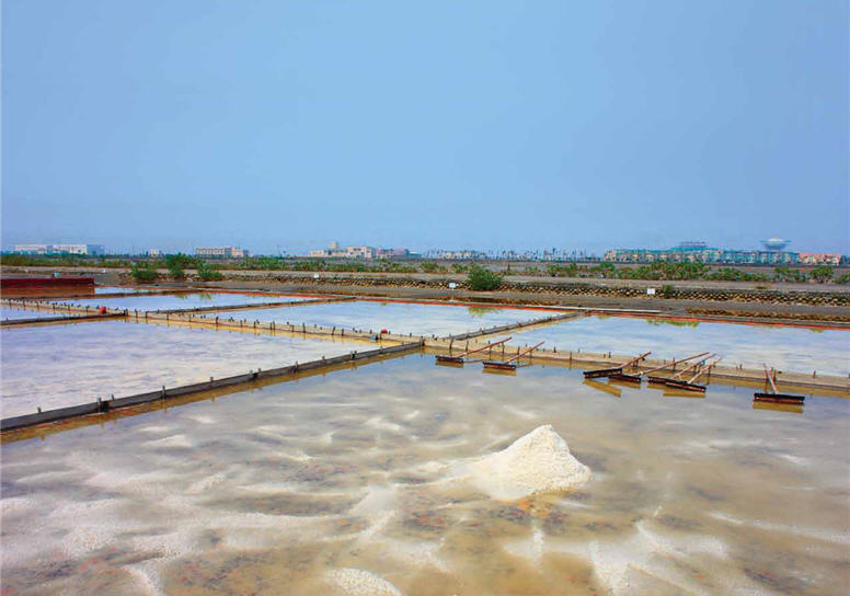
Taiwan's southwestern coast features hot summer with intense sunlight and strong winds. At the Taijiang wetland, vast salt pans and fish ponds spread under the scorching sun as thin slates of ice-like salt emerges on clay-paved ground. The area is the frontier of Taiwan's salt-producing industry and a major production site.
Taijiang's salt industry dated back to Ming and Qing Dynasties. It peaked when the Japanese turned coastal wetlands into salt pans. Anshun Salt Works was developed in 1919 as the first modern salt pan of its kind. Many neighboring harbors prospered thanks to salt shipping, and salt-producing became a major traditional industry for the locals.
Later on, salt pans diminished as a result of high production cost and the need for urban growth. TJNP managed to preserve salt pans in Qigu Wetland as well as the lifestyle led by local people for 400 years, striking a balance between conservation and economy. So far Anshun Salt Works has been re-created as a Salt Field Eco-Culture Village. The clay-paved salt pans was restored, allowing visitors to experience hands-on saltmopping, while the well-preserved salt-shipping harbor has been listed as a municipal historical site.
- upper:Brown Boobies (Sula leucogaster) had once brought to Dongsha Island an abundance of phosphate. /by Jin-zhi Gao
- lower:The wetland in Taijiang is the frontier of Taiwan's salt-producing industry and a major production site. /by Jin-yuan Dai


