
The Ever-changing Longshore Drift of the Ocean -
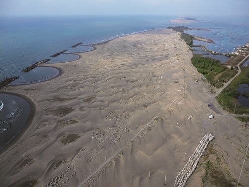
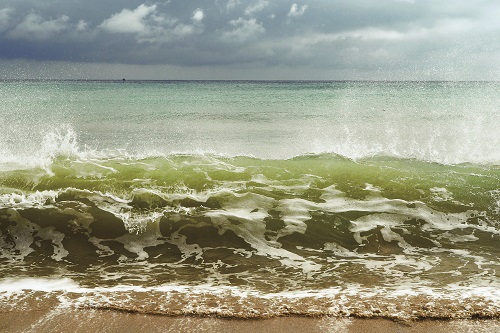
Spring at Dingtoue sandbar / Fei-Tong Shen (provided by Taijiang National Park Headquarters)
The Ever-Changing Longshore Drift of the Ocean
Article / Wei-Hung Chen
The warm southern wind is slowly ceasing, gradually replaced by the northwest gust. Wind, cools and comforts our body, relieves the agitation and mugginess of summer times. Ripple of waves appear on the calm surface of the ocean, swaying smoothly and steadily, yet is like preparing for the upcoming raging winter currents, praising, singing, reciting; this intense sound of waves is the coastal autumn song.
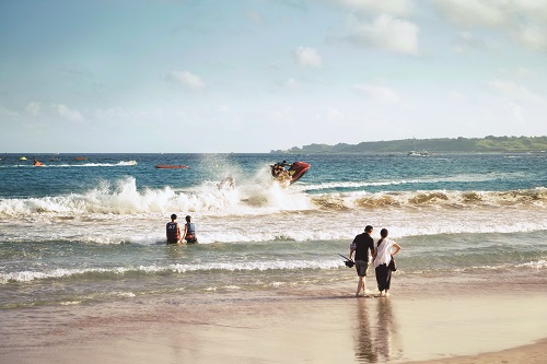
Coastline, where land and sea meets, is an ever-changing area. The unique geological features and distinctive seawater characteristics of the shoreline creates all kinds of different landscape. Some areas would form rocks and reefs of peculiar shapes; some areas would have long stretches of gravel or sandy beaches; some areas would propagate vibrant coral reefs; some areas would stand one of a kind basalt cliffs. With the in and out of the tides, the coastline changes constantly. Sometimes there is the beach stretching for miles, sometimes there is the reef exposing out of the water, sometimes there is the whitecaps overlapping on each other, sometimes there is the sparkling water shinning under the sun. The landscape would look so different even at the same location. Change, seems to be the most fascinating and yet ordinary thing of the coastline.
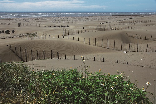
Qigu outer banks beach / Jin-Yuan Chen (provided by Taijiang National Park Headquarters)
Learning about Longshore Drift from the Changes in Taijiang’s Coastline
Taijiang region is an important waterway where ancestors crossed the Taiwan Strait to arrive in Taiwan; it is also a significant memorial ground for Taiwan’s oceanic culture and immigration history. In addition, Taijiang National Park also has unique coastal landscapes including lagoons, beaches, wetlands and estuary sandbars. Since right off the coast is a flat stretch of continental shelf, plus Taiwan’s western rivers carry large amounts of sediments, the gentle slope causes a lot of sediment to deposit in the estuary area creating natural tidal land and sandbars, which also become important living areas and cultivating lands for nearby residents.
From ancient charts drawn by the Dutch, we can see that there used to be two large scale lagoons in the Taijiang inner sea area – Daofong Lagoon in the north and Yaogang Lagoon in the south. There are also coastal sandbars of various sizes on the outer side of these lagoons. As time goes by, these two inner sea lagoons have already become a part of the land due to sedimentation, and the Taijiang inner sea is also gradually building up into land as a result of longshore drifts.
During recent decades, the three major sandbars of Qigu Lagoon area – Qingshan Harbor sandbar, Wangzailiao sandbar, and Dingtoue sandbar – have also been affected by the longshore drift, and is persistently shrinking inland and shifting southward. The originally widespread seashore, beach platform, and continuous sand dune landscape is gradually disappearing, and artificial windbreaks planted on the sandbars have also fallen due to the drifting sand. The coastal scenery is indeed changing ceaseless.
Besides being affected by the different coastal characteristics, sand and gravel brought by rivers and running water, as well as interactions between wind, waves, tides and currents, would all continue to sculpt a new coastal appearance. Even without the interference of human force, the coast would follow nature’s rhythm and cycle and change constantly. Just like the “swaying turtle tail” of Yilan’s Guishan Island and the “swaying dragon tail” of Dongsha atolls, they are all phenomenons of longshore drift on coastal beaches caused by monsoon and waves.
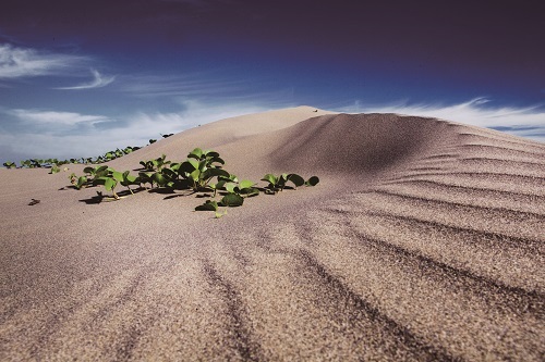
Coastal salt-tolerant plants can also play an important role in sand fixation functions. (The plant in this photo is Ipomoea pes-caprae)
/ provided by Taijiang National Park Headquarters
Longshore Drift and Coastal Ecosystems
Longshore drift is the movement of sediments such as clay and sand along a coast affected by factors including waves, currents, or tides, and does not singly refer to only the deposition or erosion of sediments; as long as there are moving sediments, this phenomenon can be called longshore drift. If the amount of sediments supplied equals to the amount of sediments lost, longshore drift is in fact not easy to be discovered. Usually it is when the dynamic is out of balance that this phenomenon is likely to be noticed. When the amount of supplied sediments is more than that of lost sediments, it will extend the beach outward or form coastal sandbars along the shore, or even create natural tidal lands. On the contrary, if the amount of supplied sediments is less than that of lost sediments, the beach along the coast would shrink or disappear, or even eat away the land.
Each coastal strand carries its own ecosystem. Some natural beaches are flat and have a wide area of intertidal zone, but the flora is limited and covers only a small area; some have well established natural maritime forest and supports a great diversity of plants and animals. In general, the slower the change of an environment, the better the opportunity for its ecosystem to establish, and the more comprehensive the ecosystem is, the more it has the ability to fight against the elements of the environment. Therefore, if under natural succession, longshore drift is in fact neither good nor bad, it can be viewed as a part of the natural process. However, the actual longshore drift situation we are currently facing, is that there are too many human activities and facilities interfering, making a rapid alteration in the longshore drift phenomenon, resulting in dramatic changes in the coastline, which not only affected the appearance of land, but also impacted the coastal ecosystem, and disrupted the natural succession and dynamics.
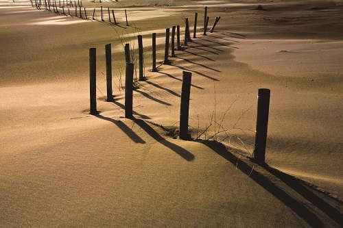
Longshore drift is the movement of sediments such as clay and sand along a coast affected by factors including waves, currents, or tides.
/ Szu-Chi Hsu
Despite Taiwan’s abundant rainfall, it is within the top 20 countries in the world facing water shortage. This is because the surface water only stays on the surface for a very short period of time, and will quickly flow into the sea due to Taiwan’s abrupt geographical features and dense population. To solve this water shortage problem, reservoirs are set up at many rivers upstream, with the intention to retain the water for everyday living, agricultural and industrial use. However, a significant amount of sediments are also intercepted by the reservoirs, and the volume of deposits that are originally invented to supplement the coastal areas have been reduced, causing beaches to disappear due to erosion from currents and tides.
In addition, Taiwan has set up many fishing ports and groynes, which not only made natural coastal environment disappeared, but also changed the flow path of longshore current, making the flow on the updrift side deflect toward the open sea, and sediments being intercepted and built up in the direction of longshore drift; at the same time, erosion starts to appear on the downdrift side where it is receiving little or no sand, and this phenomenon is referred to as terminal groyne syndrome. Therefore, we often see the groynes would slow down the impact on one side of the structure but accelerate erosion on the other side, which we can say is not a permanent solution for coastal protection. It is merely shifting the location where longshore drift happens, and may even bring more problems.
It goes without saying that development of coastal areas would directly affect the dynamics and balance of longshore drift. Ecological and sand drift problems caused by inappropriate coastal developments have gradually emerged. In severe cases, coastal land were lost and the economy of the coastal areas were deeply impacted. So how do we truly protect the sea? We must start by “knowing”. Let us cut right into the problems caused by coastal longshore drift, and get a better understanding of the difficulties National Parks are facing in their coastal areas.
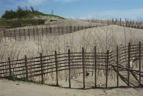
Taijiang National Park uses natural materials to set up sand fences. / Cheng-Yi Chen (provided by Taijiang National Park Headquarters)
Longshore Drift in National Parks
Taijiang National Park – Sand Fixation Defense
Of all the National Parks, Taijiang has the most longshore drift happening within its boundaries. In early years, rivers would carry tons sediments downstream with them, creating large amounts of sandbars along the coast. But in recent decades, affected by the construction of reservoirs and weirs upstream, coastal sandbars in the Qigu Lagoon are gradually shrinking and disappearing. To slow down the erosion process caused by longshore drifts, Taijiang National Park Headquarters took use of the scattered driftwood and bamboo frames on the beach and piled them up to make three artificial sand dunes on the Wangzailiao sandbar. They not only can effectively intercept the sand carried away by the wind, but also continuously gather sand and expand the sand dune; when the waves hit, these sand dunes can also block out part of the impact, as well as enhance the natural sand fixation ability of sandbars. Because of them, storm surges and waves during typhoon season would not scour through the entire sandbar, which would give the plants on the sandbar a chance to recover and propagate.
When these vegetation are established and thriving, they can also provide decent sand fixation and sand gathering ability. With these two elements complementing each other, they would provide the coastal ecosystem a brand new kind of natural appearance.
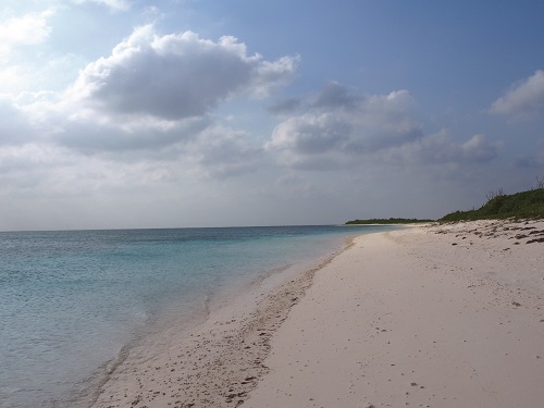
The wide stretch beach at South Bay / Szu-Chi Hsu
Kenting National Park – Continuous Surveillance
Kenting National Park Headquarters have conducted research on six beaches within its borders at Baisha, Houbihu, Big Bay, Little Bay, South Bay, and Sail Rock, measuring their changes in size in the year 1982, 2002 and 2006. The method they used to measure and compare the area is by using aerial photos taken by the Forestry Bureau Aerial Survey Office. The boundary of each beach is marked for calculation, and then compared among the different years.
Results of this study showed that there were no significant differences in area of these 6 beaches among the three years investigated. That is the area of the beaches did not have any major changes; they did not erode inward nor extend outward, and that longshore drift did not have serious affects to the environment. However, this report also brought up some questions regarding the sampling method. The aerial photos used for comparison were taken by the Aerial Survey Office after typhoons hit, and the appearance of the beaches may be different than those during normal times; therefore, the report also stated its reservations regarding the no differences outcome.
Observation and monitoring the location and size of the beach is a way to understand the situation of coastal longshore drift. Regular monitoring of the beach location and variations or changes in beach areas, would help master the longshore drift condition in these areas, and establish a suitable sand fixation plan. However, in the early data collection stage, it requires not only long-term and continuous recording, but also paying attention to many details; information such as method of monitoring, location of monitoring points, and monitoring time points are all important data records for longshore drift studies. In some areas, sand will drift in seasonal cycles, so data of the entire four seasons have to be covered when investigating, otherwise it is easy to generate misjudgments. In addition, besides horizontal changes in the surface area, longshore drift sometimes will also cause vertical elevation changes of the beach; therefore, vertical records are also very important. The typhoon records in this report will also need to be treated separately in order to understand the differences between changes under regular state and special weather conditions to make the information collected even more complete.
Berm and beach along Dongsha coastline / Mr. Liao
Dongsha Atoll National Park – Observation after Shore Protection
The beaches of Dongsha Atoll are mainly composed of coral sand, and the longshore drift here is affect by a combination of environmental factors including surrounding waves, tides and depth of the ocean. Affected by the seasonal storms, the northeast monsoon prevails during winter, and will cause the spit of Dongsha Atoll extend southward from the southeast end of the island; when summer arrives, the wind turns southwest, and the tip of the spit will slightly turn from south to north. This seasonal shifting of the spit is commonly referred to as the “swaying dragon tail” of Dongsha Island. It is a seasonal and regional characteristic of Dongsha Island’s longshore drift. However, due to coastal erosion problems, the Naval Engineering Depar tment has set up 14 revetments and groynes along the shoreline of Dongsha Island to slow down the erosion, but it also caused the phenomenon of the swaying dragon tail to disappear.
Through numerical analysis, Marine National Park Headquarters has simulated the coastal flow fields and sediment transport ability of each atoll areas. Result shows under the influence of strong waves during a typhoon, longshore drift is the strongest around the dragon tail, which means this area is relatively vulnerable to erosion. Besides winter times, the location where longshore drift is relatively more active, is in the waters west of the groynes at the south end of Dogsha Island, but will weaken when winter comes. During winter times, the north shore of the Dongsha Island lagoon shows phenomenon of moderate deposition caused by longshore drift.
Using numerical simulation to calculate the area and the amount of sediments being moved helps us to understand the degree and scope affected by the longshore drift. In areas that are necessary for human intervention, develop sand fixation method that is most effective and yet has the least interference to the natural environment. For the groynes and revetments that is unnecessary, we also have to contemplate on how to salvage and rescue this diminishing natural shoreline.
The accumulation and bulging of sand has not stopped, and the erosion and weathering of the shoreline has yet to cease. / Szu-Chi Hsu
A Drifting Dynamic Balance
Among different time scales, longshore drift can give us totally different feelings. In a short period of time, the drifting sand is like flowing in a massive ocean hourglass, bit by bit and yet not easy to notice; but if we look at it from a decade or longer time point, perhaps we will feel the changes of time, and be shocked by the alterations of the coastline can be so drastic and terrifying. On the other hand, if a beach seems unchanged for a decade, does it mean the sand has never drifted?
Many things seem to be immutable, like the alternating of night and day, and the change of the four seasons; they all appear to be reoccurring in cycles, but in fact every day is a new day, and every season is a new season.
The rotation and rhythm of the earth never stops, the dynamics and succession of the natural environment is also carried out continuously. The accumulation and bulging of sand has not stopped, and the erosion and weathering of the shoreline has yet to cease. The landscape appearance of what we see right now, is through 4.6 billion years of shaping done by the earth; the immediate world and environment is not immutable, but rather changing constantly. Longshore drift is a part of the natural process, only by accepting the existence of longshore drift, and mitigate and adjust through natural approaches, can we save and recover the original protection function of the coastline.
About the Author - Wei-Hong Chen
Graduated from Graduate Institute of Environmental Biology and Fisheries Science, National Taiwan Ocean University.
Former editor of textbooks and environmental protection educational materials.
Currently engaged in science, environmental education and text compilation work .


