
Tour of the Secluded Jinbaoli Trail-Intertwining Footprints of Marriage, Economy and Military
This trail was an ancient path Jinshan ancestors took to Taipei for matrimony,
as well as a convenient route for transporting sulfur, indigo and tea.
Later, it fell into military use during the era of foreign rule
Author | Lu, Li-chang
The author has a rich background in natural ecology and is a senior member of the national park administration. Extremely familiar with Yangmingshan National Park, every detailed cultural and ecology story is at his fingertips.
of Taiwan and the northern part of Taipei Basin (on the left is Sulfur Creek Valley). / Pei-Chi Wang
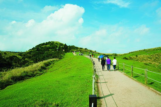
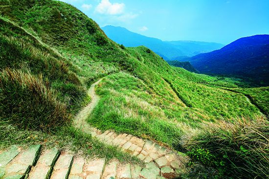
Qingtiangang Trail is a very popular tourist trail / Huai-Chi Yang
An Everyday Route Among the Tribes
Also known as the Fish Road Historic Trail, Jinbaoli Trail is an important link between the north coast of Taiwan and the Taipei Basin in the northern region. In the earliest days, this trail linked the Austronesian Ketagalan people of the Jinbaoli communit y to the Kimassauw community via the Datun Volcano Group, and also to other villages in the Beitou community. Today, many traces of indigenous settlements and archaeological sites can still be found along the way. The indigenous Pingpu people associated with the ancient trail can still be found in the Greater Keelung community, the Smaller Keelung community, the Datun community, the Guirou community, the Tamsui community, the Halapei community, and the Outer Beitou community. During the early days of the Pingpu tribe, Yangmingshan and its neighboring regions were the traditional spheres for their daily lives. Ancient shortcuts were used for hunting, vine harvesting, sulfur mining, field burning and planting, and also served as an important path for trading, marriage and information exchange among the tribes.
Han Settlement
During the navigational era of Xihe and Ming Zheng, pirates and Wokou ( Japanese pirates) raided the coast, and colonial rulers were occupied with searching for sulfur, coal, gold and tradable resources such as timber, deer hide and cane palm, making the ancient trail very important. At the beginning of the Qing Dynasty, Lohan-Jiao (single, male vagabonds) risked their lives and crossed over the Taiwan Strait from Fujian Province. These Quanzhou, Zhangzhou and Hakka immigrants came to the Tamsui River and the northern coast of Taiwan, and rented land from the Pingpu people. They began their settlements along river ports, plains and terraces, and continued to settle into the mountains, marr y into Pingpu families, or hire themselves out as laborers for Pingpu businesses. Due to their growing population and family livelihood, they needed to expand their living space, and via the ancient trail, continued up into the mountains to establish traditional settlements.
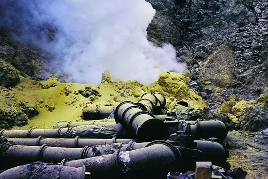
Jinbaoli Trail was at its most prosperous during middle and late Qing Dynasty. The Convention of Beijing opened up five ports, and sulfur, camphor, indigo, coal and rice became important export merchandise. Moreover, from 1851- 1861, tea seedlings and tea seeds were imported from Fujian and cultivated. In 1865, the British merchant Dodd brought in funds. Using the Pingpu land in the Beitou community and Kimassauw community and labor from the Lohan-Jiao immigrants, he cultivated tea plantations on the mountainsides of northern Taiwan, such as Yangmingshan. River valleys and forested areas were also planted with hill indigo plants for blue dye, forest wood was made into charcoal, and camphor trees were felled to extract camphor. The Han people continued to open up areas in the mountains through the ancient trail; thus, Jinbaoli Trail is a sulfur, camphor, blue dye, tea picking and charcoal transport path beaten out by the ancestor one step at a time. In Taipei Basin, expanding farmland increased the demand for buffaloes, and from the end of the Qing Dynasty to the early days of the Japanese occupation, more than 1,700 buffaloes were kept in the nearby Daling (Qingtiangang). Farmers herded the buffalos through Jinbaoli Trail, turning the ancient road into a cattle trail.
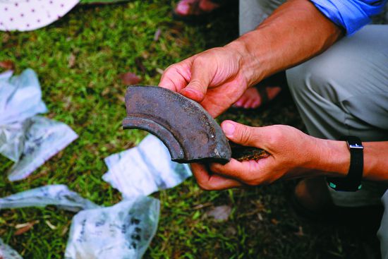
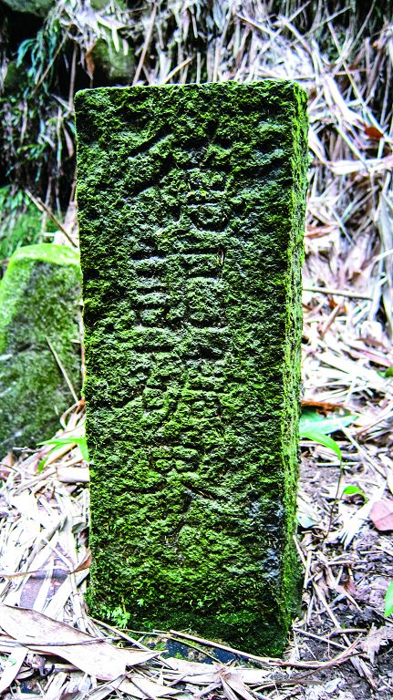
can be found in sulfur mine garrisons such as the Jixinlun Henan garrison in Lengshuikeng
and the Shou-Kuang garrison in Dayoukeng.
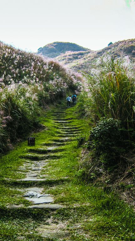
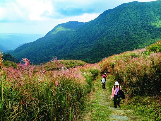
The roadbed was paved with slate, with many inclines and steep steps. / Pei-Chi Wang
Henan Army Trail and Japanese Trail
The surrounding areas in Cising Mountain were rich in sulfur, which were often stolen by thieves to make gunpowder, thereby creating trouble. From 1735-1795 after the Lin Shuangwen rebellion, sulfur was banned all over the island. The Qing government sent the Henan Navy to patrol the sulfur-producing areas every year and banned mountain burning. Thus Jinbaoli Trail became a major military trail for the Henan army patrolling the sulfur stations. In many sites, such as the Jixinlun Henan garrison in Lengshuikeng and the Shou-Kuang garrison in Dayoukeng, many ceramic bowls left behind by the Henan army can be found. Hence Jinbaoli Trail was also a Henan army trail during the Qing Dynasty.
In the early days of the Japanese occupation after the disintegration of Taiwanese democracy, anti-Japanese Chien Ta-Shih guerrillas gathered in Caoshan. Chien Ta-Shih launched a guerrilla war and challenge against the Japan Guard by burning garrison camps such as Shaogengliao, Dalingchengmen (Qingtiangang), and Donggua Lake (Dayoukeng) stationed along Jinbaoli Trail, turning the trail into Bandit Road. In 1898, after the Chien Ta- Shih surrendered, the Japanese commissioned the construction of a road adjacent to the contour line of the Henan Army Road for combat preparations. This zigzagging Japanese Trail, which is wider and more gradual, intersects with the Henan Army Trail at several points.
Japan's Governor-General Office actively promoted afforestation and recreational mountain hiking in Caoshan, and developed the Datun Nature Park Project, turning Jinbaoli Trail into a path for seedling cultivation, mountain hiking and environmental education.
Later, the opening of the Keelung- Jinshan and Tamsui - Jinshan highways replaced Jinbaoli Trail for transporting goods between Taipei and Jinshan, and gradually the ancient road fell into disuse and decline. However, due to the large population increase in Taipei during the Japanese occupation and the outbreak of the Greater East Asia War at the end of the Japanese occupation, goods were under wartime control. So with fish smuggling, Jinbaoli Trail received a new lease on life, and was called “Fish Road” by the locals. Hence the origin of the name Fish Road Historic Trail. Due to convenient transportation and the opening of the Yangjin Highway after the war, Jinbaoli Trail was buried in neglect. After the establishment of Yangmingshan National Park, parts of Jinbaoli Trail were restored to meet the needs of hikers, nature trips and environmental education.
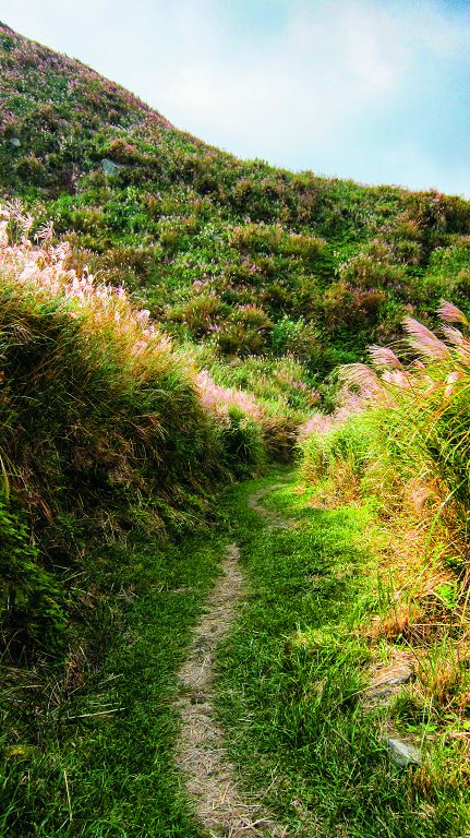
adjacent to the contour line of Henan Army Trail. Zigzagging and more gradual,
this road intersects with Henan Army Trail at several points. / Pei-Chi Wang
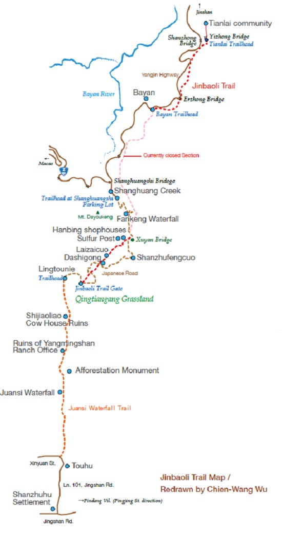
Starting from Jinshan-- Tour of an Ancient Trail
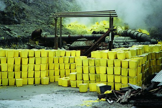
Jinbaoli Trail begins at Jinshan and ends in Shilin via Qingtiangang. It has an abundance of natural ecological and geographical landscapes along the way and a rich variety of ancestral ruins and settlement sites. In the early days, the Jinshan sulfur port was an important export port on Fish Road Historic Trail for goods such as sulfur. On the other side, separated by Shihtou Mountain, is Shuiwei Port, a beautiful sand shore. Stacks of sulfur blocks were temporarily stored next to the port, and stone steps lead to Jinshan Old Street. Along the old street is the Cihhu Temple for worshipping Matsu, and the Guang An Temple for worshipping General Chen Yuanguang. The quaint old streets still bear witness to the prosperity of Fish Road Historic Trail.
Along Jinbaoli River, past the lush green farms of Yuemei, is the old settlement of Nanshi Lake nestled in the small hills. In the distance are the Jinshan plain and Jinshan coast, and to the right is the beautiful Dadu Meiren Mountain and the winding Northern Sulfur Creek flowing into the sea. Stone houses and courtyard houses are scattered among the terraced farmlands. Along the ancient trail are 6 ancient ancestral graves built between 1875 and 1908, with the Earth God donning red official headwear. Past stone bridges, vegetable gardens, ponds, Tujiaocuo and arriving at Changtian Shore is the most beautiful view of terraced farmlands which have been abandoned. Following Jinbaoli River to its source, primitive natural ecolog y can be found along the ancient trail next to the turbulent water. In addition to a variety of vegetation, macaques, pangolins and other wild animals can also be commonly seen.
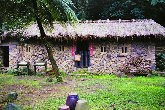
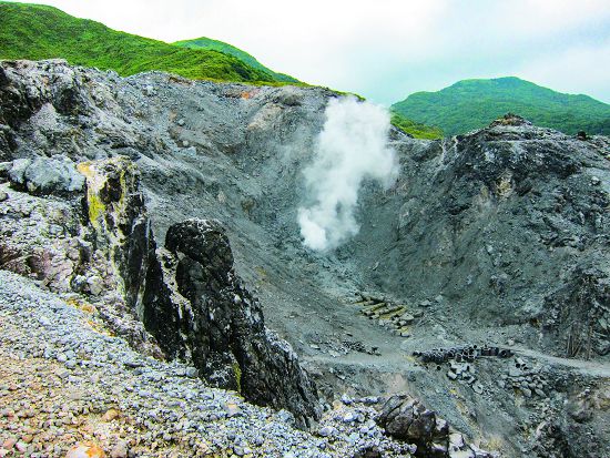
Next to the entrance of Dakongwei Trail is an abandoned stone house. After the Dakongwei Bridge is the Tianlai community, once known as Jinshan Farm. It is also the Jinbaoli Trail entrance into the Yangmingshan National Park, and following the Cijiao stone steps past Gaocuo is the Bayan settlement. In 1852, when hiking through the Fish Road Historic Trail, explorer Swinhoe praised Bayan as being the most beautiful landscape along the trail. Bayan was so named because of the curling smoke from the sulfuric fumaroles. Stone houses, terraced farms, ruins of sulfur and gold mines, the Deji iron fertilizer factory, Earth God temples and courtyard houses can be seen in Bayan, and together with the distant mountains, Bayan is an ideal place for experiencing both nature and culture.
The section from Bayan to Shanghuang Creek is currently closed. After Bayan, it is necessary to backtrack to Yangjin Highway to access the trailhead at the Shanghuang Creek parking lot to return to Jinbaoli Trail. The Xuyan Bridge on Shanghuang Creek can be reached by following remnants of the original stone steps through Shaodianzidi, Fankeng Waterfall, and the ruins of the Xubangzhi historic stone house. This stone arch bridge was built by Xu Qingyan, a Shimen tea merchant in the early days of the Japanese occupation. After being destroyed by a typhoon, the bridge was eventually restored by the National Park.
Across the bridge are the ruins of stone houses used by earlier sulfur miners and subsequent farmers, and settlements such as Lianchengcuo, Hanbingcuo, Caiyuancuo, the new Xubangzhicuo and Laizaicuo. Stone quarries, Hanbing shophouses, Qing dynasty official residences, sulfur posts of the Henan Army and Mao Shaoweng community, the largest volcanic crater landscape in Yangmingshan and ruins of sulfur mines can also be seen.
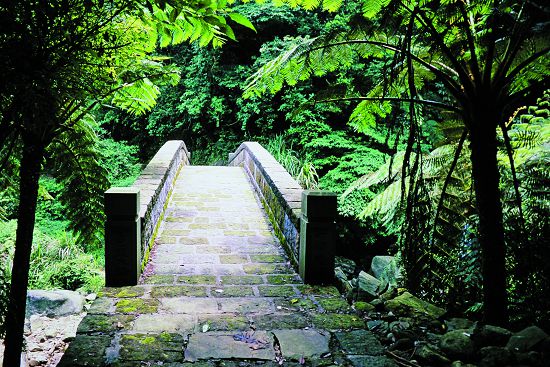
and later restored by Yangmingshan National Park Headquarters.
Continuing on through the Dashigong scenic point, Jinbaoli Trail inclines steeply to Daling (Qingtiangang Grassland). Along the way are Hundred and Twenty Stairs Trail, Shueiyuandi, Yuanshan, Ercengping , Shizitou, Xiaoren Cemeter y and Henan Garrison leading to the city gate. Near the city gate are the headquarters of the anti-Japanese Chien Ta- Shih guerrillas, the Taisho era afforestation monument, the Chaliao ruins, ancient defense fortifications and defensive fighting positions. In Daling, in addition to the Earth God of Lingtounie, anti-communist memorial pavilions, military camps, bunkers, cattle barns and ancient tombs can be seen. These relics from several different eras seem to epitomize time and space. From the high points of the grassland, the distant Shamao Mountain, Tamsui River and Jinshan Plain can be seen.
After enjoying the vast beauty in Qingtiangang, the Juansi Waterfall Trail leads to the Jixinlun Henan Garrison, Wuqiao Shueiyuandi, ruins of a ranch office, Sankong Spring, the afforestation monument, Juansi Waterfall and Touhu Ancient Canal, then down to the abandoned Touhu Earth God Temple. From here, Jinbaoli Trail gradually winds through the Wild Boar Lake Settlement and exits Yangmingshan National Park. Going along Jingshan Road and passing through the Jingshan sulfur shed, the road leads to the intersection between Pingjing Street, then passes through Dacuodi, Shaogengliao, Waizhuang, Lingding, Bazipu, Taiwan Theological College and Seminary in Shijiao, and down the stone steps behind the National Security Bureau to Zhishanyan. Finally, going along the banks of the Shuangxi River through the Shennong Temple on Qian Street in Shilin and the Cixi Temple on Hou Street, the road leads to Shilin Fish Market where fish and other goods are sold, or ferried to Dadaocheng or Tamsui for sale or export.
Jinbaoli Trail (Fish Road Historic Trail) has an abundance of natural ecology and ancestral settlements, cultural relics and historical sites. The ancestral wisdom for survival and revelations of nature are explained by the National Park tour guides as they lead the public and students through the ancient trail in a richly rewarding environmental education and cultural experience.
cultural relics and historical sites, making it an ideal place for hiking
and environmental education. / Huai-Chi Yang


