Digitally Monitoring the Pulse of Everything-

Digitally Monitoring the Pulse of Everything
Article/Chih-Ya Cheng
Interviewees/Mei-Hsiu Hwang, Professor, Institute of Wildlife Conservation, National Pingtung University of Science and Technology Hung-Chiao Chen, Technical Specialist, Conservation and Research Section, Kinmen National Park Headquarters Yu-Jen Chang, Director, Xiaoyoukeng Station, Yangmingshan National Park Headquarters Guo-Jing Weng, Professor and Director, Institute of Wildlife Conservation, National Pingtung University of Science and Technology
Over the years, we have heard more and more that particular animals or places are being “monitored”. Why do we need to monitor nature? How should we monitor? For how long? In particular, as digital technology advances year after year, there are more and more ways to monitor. The trend is toward collecting and analyzing basic survey data more efficiently, including automatic cameras, ultra-high-frequency radio transmitters, artif icial satellites, aerial drones, and so on. But what are the benefits of digital monitoring for ecological research, conservation, and restoration? And what does that all mean for us?
A Dashcam for Critters
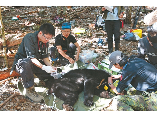
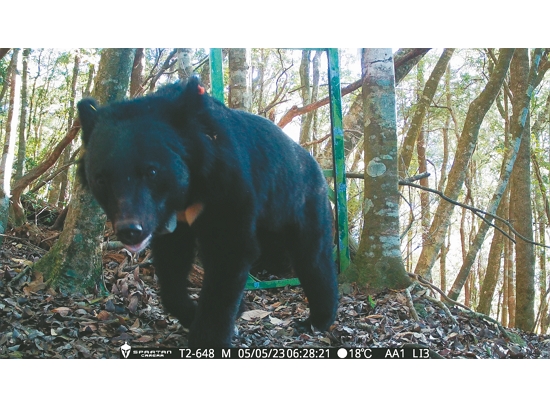
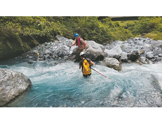
Recently, there was yet another news story in the Taiwanese media about an injured Formosan black bear being released back into the forest after treatment. The group who did the release took the opportunity to attach a transmitter to the bear’s neck, so they could track the creature later. But this animal is not the only one being monitored. Since 2019, Yushan National Park Headquarters (“YSNPH”) has also commissioned an expert team led by Mei-Hsiu Hwang (professor at the Institute of Wildlife Conservation, National Pingtung University of Science and Technology) to carry out the three year Formosan Black Bear Artificial Satellite Tracking & Ecological Monitoring Program. In these three years, what mysteries have we solved about the Formosan black bear ?
Hwang first explains the selection of monitoring equipment. She notes that, in wildlife research, it is sometimes possible to observe the animals directly with the naked eye. For example, Formosan macaques in hills are more accustomed to the presence of humans than are other wild animals; they aren’t very skittish around people, and pose relatively smaller immediate threats to human beings. That means someone studying macaques can directly observe and record their behavior.
“However, for animals that are highly secretive,” says Hwang, “almost all of them have to be tracked by equipments if we want to understand their habitats and behaviors. This includes tracking when and where these animals appear, and even going where they have been to observe what the animals have been doing, etc. Therefore, ground radio, satellite tracking, and automatic camera detection are all important tools for wildlife research.”
VHF(very high frequency radio waves)- or satellite based tracking and monitoring is where a wild animal is first captured by researchers, then the animal is given a transmitter that looks like a collar. The transmitter is similar to the Global Positioning System (GPS) that we all know so well. After the animal is released, the transmitter sends a signal back every set interval. This way, the researchers know where the transmitter is currently located; the overall record forms allows researchers to trace the animal’s movement patterns.
The Formosan Black Bear Artificial Satellite Tracking & Ecological Monitoring Program, as its name implies, uses satellite tracking. Hwang says, Since 1998, I’ve been doing research at Yushan National Park, we’ve used three monitoring methods – kind of like how you might combine GPS with a dashboard camera. We’ve used VHF radio tracking, satellite tracking, and automatic camera detection. And the satellite tracking data we’ve collected from within Yushan National Park is probably the richest and deepest in the whole of Taiwan.”
However, Hwang emphasizes that no monitoring method is perfect: “VHF radio technology is less expensive, but requires someone to track the animal from the ground for it to work. Also, the monitoring area is relatively limited due to rough terrain and road system limitations. Satellite technology is more expensive, meaning the number of animals you can monitor is much more limited.” And whether tracking via radio or satellite, we have to capture and place transmitters on the animals; and cause some disturbance to animals. In addition, we can track the movement of animals to understand how they’re using the environment at different times, and seasonal movement paths and activity ranges
「 “Comparatively speaking,” notes Hwang, “automatic cameras are less expensive and less invasive. However, an automatic camera can only shoot from a fixed location. The detection area is about 10 meters in front of the camera – in other words, the animal has to pass in front of the camera before the camera can detect and take pictures of it. And the camera’s location is sometimes very important. If we place it near a bear den, for example, then we may get a lot of bear pictures – but they turn out to all be the same bear.” However, despite their limited imaging ranges, automatic cameras are easy to operate. And with the long-life batteries available these days, it’s not a problem to leave a camera in the field for half a year. That’s why automatic cameras continue to be widely used in wildlife research today
VHF Radio or Satellite Positioning ?
Radio tracking systems include traditional VHF and satellite positioning. Radio positioning requires researchers to carry receivers on the ground, then follow the transmitters around. When they get stable, strong radio signals within a certain range, they can confirm the target’s location with triangulation. Satellite positioning, on the other hand, uses the Global Positioning System (GPS), based on the length of time it takes for signals to be sent and received, the location of the target can be deduced.
Telling the Bear Story to the Fullest
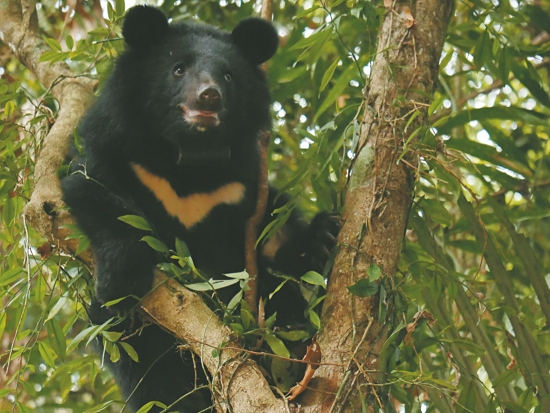
Hwang states that there are currently only two areas in Taiwan where Formosan black bears are captured, released, and radio tracked in the wild: Daxueshan National Forest Recreation Area, and Yushan National Park. Hwang notes, I’ve accumulated a sample size of nearly 30 black bears in Yushan National Park since 1998.”
Viewed from the macro scale, the large number of animals monitored in Yushan National Park and the long time scales over which they’ve been monitored have resulted in quite a rich dataset(Although not consecutive). This has helped researchers better understand whether Formosan black bears have seasonal migrations, and what kinds of places they prefer to live in. Hwang shares that in this current program, up to six bears can be captured and released within a single year, And perhaps even more interestingly, in addition to tracking to the east, the research team has also tracked three bears for the first time in the more westerly area stretching from Tataka to the Nanzixian River. For the first time, Formosan black bears have been captured in the western part of Taiwan. “It turned out that three of them are male bears.”
Why, then, were more male bears caught this year? Hwang explains: “Past studies have shown that the gender ratio of healthy populations in the wild is normally 1:1. But with the low sample size, it isn’t appropriate yet to conclude why all the captured bears were males.” However, this program’s tracking did reveal that the tracks of the six bears in east and west did not overlap. This suggests that they did not interact with each other; but this also doesn’t mean that they don’t move across the Central Mountain Range, as previous studies have shown that bears from the east have at times moved to the west. The natural and man-made environments in the east and west central mountains of Yushan National Park are very different. Through this study, we hope to understand the adaptability of the Formosan black bear in different landscape environments.
However, due to conservation law, administration regulations and budget allocations, the implementation period for each research project and the number of animals that can be captured and released is not very large. The research team thus tries as much as possible to combine previous monitoring data with current satellite data. “After all,” says Hwang, “for a long time, we’ve been doing capture and release of wild bears and research work in Yushan National Park. We and YSNPH both want to tell the story more clearly. It’s not that there are six bears wearing collar transmitters this year, so we’re only writing about those six bears; rather, we’re taking all the data we’ve obtained and putting it together, to study and analyze it. We’re trying to see how we can tell the story of the bears in a more complete way.”
Hwang also talks enthusiastically about the work and scope of application of the consolidated data. “Next, we will use this valuable satellite tracking data to further analyze and assess habitat suitability. Yushan National Park is so large that there may be 200 or 300 bears living there. But we’re actually tracking only a few of them, and in some places, we completely don’t know what the bears’ status is.” Consequently, the team will use existing tracking and monitoring data, together with environmental factors, to better understand the data correlations. They will then map these individual observations onto to the whole of Yushan National Park, in order to make inferences about the habitat quality and distribution status of Formosan black bears.
“In other words,” says Hwang, “we aim to understand the preferred living environment of Formosan black bears. Like, we want to identify the core and the peripheral areas where Formosan black bears live. We’d like to complete a predictive map of well-suited habitats for Formosan black bears in Yushan National Park.” For some hot spots where black bears are found, the team has tried to further map out what factors influence the frequency with which bears are seen in the area. This has included plant composition, human interference, such as whether the distance of roads and settlements influence where bears are seen, and other factors. Hwang emphasizes this point: “The more data we have, the more accurate the maps will be.” This predictive map will not only help in ecological conservation, but also provide YSNPH with critical, specific data for operational management.

“Every Bear is Like One of Our Children”
When attaching a collar transmitter to an adult Formosan black bear, the principle of “maximum looseness” is applied. That is, a collar needs to be as loose as it can be while making sure that the animal can’t remove it with strong tugging. This way, if the animal gets fat later on, it won’t be constricted by the transmitter. The researchers also set the transmitter to track for two years; once the time is up, the collar comes off automatically. Hwang adds, “Sometimes, if there’s an emergency, the researchers will send a modified instruction to the transmitter, from within the transmitter’s receiving distance (usually 500 meters). We can tell the transmitter to drop off immediately; it won’t stay around the animal’s neck.” During the monitoring process, animal welfare is always a concern for the research team. “Every bear is like one of our children; we have a responsibility to them. In fact, throughout the monitoring process, no one on the research team ever lets up on this kind of diligence.”
A Silent Coast’s “Metamorphosis”
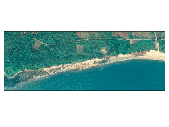
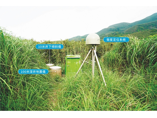
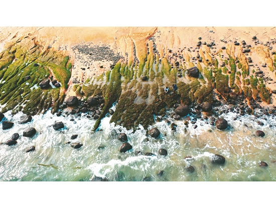
In addition to biological monitoring, monitoring systems and programs for environmental research on topography, geology, and meteorology have also been intensively under way for many years. For example, for the past decade, Kinmen National Park Headquarters (KNPH) has implemented the Important Coastal Landscape Topographic Variation Monitoring Program since 2013; and Yangmingshan National Park Headquarters (YMPH) has added the Xiaoyoukeng Trail Vent Migration and Near-Surface Hydrothermal Fluid Distribution Investigation Program in recent years.
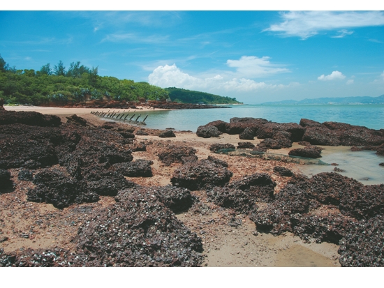
Hung-Chiao Chen, Technical Specialist, Conservation and Research Section at KNPH, explains the origins of the monitoring program. “There was military control of Kinmen in the early days, so the public couldn’t approach the coastal area whenever they wanted to. Later, when military control ended and coastal demining officially ended in 2013, we wanted to establish a basic data set on the physical environment and biological resources along the coast. That was when routine coastal surveys began.”
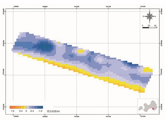
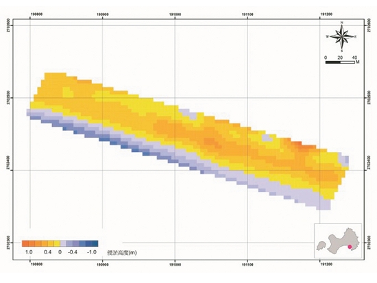
She adds another reason: After the end of the military control, more and more people went to the beach, but there are many vertical cliffs along the coast of Kinmen, and there are often sand pumping operations in the sea near Xiamen. In order to ensure public safety and to understand whether human development or meteorological changes could cause coastal erosion, it was necessary to analyze the changes in the overall coastline through long-term monitoring. That required recording current conditions in exacting detail, then cross checking each data point against the past data.
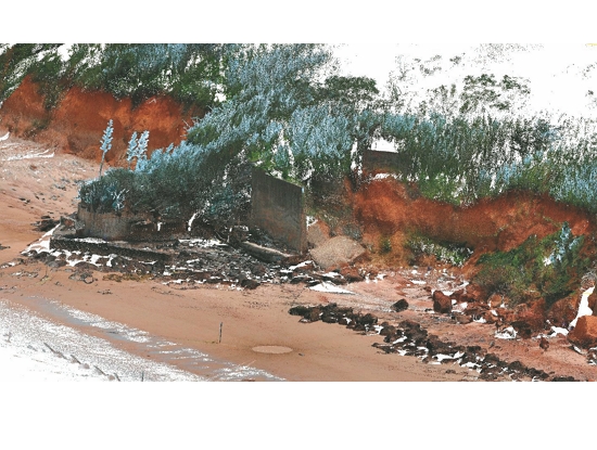
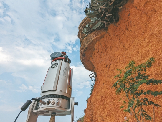
During the recent 2023 project, two moderate typhoons occurred. Therefore, after the two typhoons, the research team carried out real time kinematic (RTK) beach elevation measurements, uncrewed aerial vehicle (UAV) photography, and other specialized measurements on important beaches such as the Guningtou Beishan cliff coast, Guningtou Beishan seawall coast, the Jinhu Xintou coast, and the Lieyu Huangcuo coast. The data from these operations, combined with previous data including aerial photographs provided by the military, allowed building a 3D model to show differences in coastal elevations at different times. Chen notes, “We now better understand the details of the landscape pattern in some places; and those details would have been hard to see from the previous military aerial photographs.”
In the past two years, the monitoring program has included construction of self-logging meteorological stations and analysis of sediment particle size in beach areas. This has mainly focused on changes in rainfall and soil moisture in coastal areas, as well as investigating sediment composition and more. “The overall basic data collected will help us better understand the profile of the Kinmen Coast, and provide us with useful, accurate assessment data for environmental protection and project planning in the National Park. It can also be applied to other fields, such as meteorological research and maritime transportation.”
In addition to changes in monitoring methods and technologies, the objectives of monitoring also differ from those in the early days. “In the past, we might focus on what was causing changes,” says Chen. “But now we’re more concerned with development trends. That goes in line with the concept that ‘an ounce of prevention is worth a pound of cure’. That is, we hope that once we’ve accumulated some data, we can find a wide range of specific applications. For example, once we’ve cross-checked the self-logging meteorological stations we’ve set up and the changes in beach surfaces after the typhoons, that not only provide reference data for predicting a typhoon’s movements, but if there’s a storm of similar magnitude in the future, the data also helps us alert the public whether to steer around certain sections of road to avoid sea cliffs collapses, etc.”

Real-Time Kinematic
Real-time kinematic (RTK) beach elevation measurement is a highly accurate positioning technology. RTK uses global satellite navigation systems to measure the height (elevation) of a beach, that is, the vertical distance from sea level to a certain point. This helps the research team to visualize changes in beach elevations, coastal erosion, and accretion.
Listening to the Heartbeat of the Earth
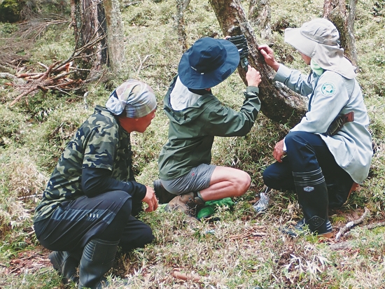
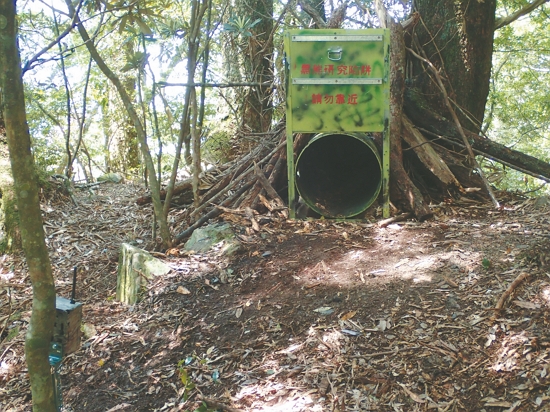
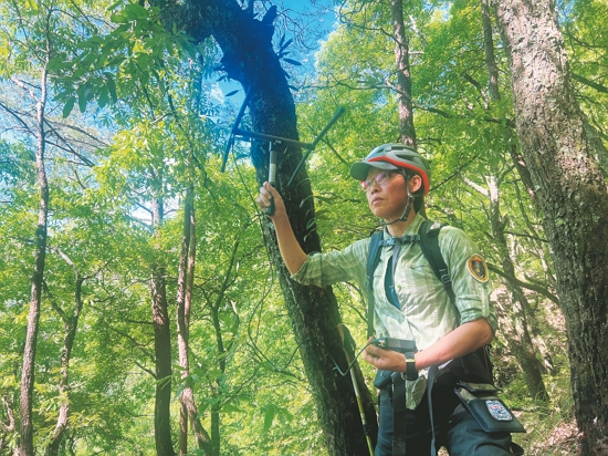
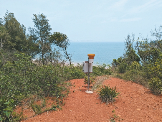
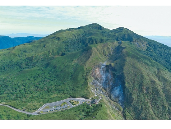
The concept of “an ounce of prevention is worth more than a pound of cure” can also be found in the volcanic movement monitoring program at YMPH's Xiaoyoukeng Station. Prior to this monitoring program, the Ministry of Interior and the National Science and Technology Council had already build the Datun Volcano TVO within the Jingshan Nature Center of YMPH in 2011, and conduct volcano monitoring research under the leadership of Professor Cheng-Horng Lin. In recent years, in order to further supplement that supplement that data of near-surface volcanic hydrothermal solution, YMPH chose to initiate the investigation and analysis of the subsurface electrical structure, near-surface volcanic hydrothermal solution distribution, and composition of rocks in the Xiaoyoukeng area, where there are both active volcanic gases and an abundance of tourists.
It sounds quite specialized and complicated, but Yu-Ren Chang, Director of Xiaoyoukeng Station, tries his best to explain it thoroughly: “Volcanic gases are mainly composed of magma gases and hydrothermal gases. When we go to Xiaoyoukeng, what we see most often is the volcanic exhalation phenomenon. There are two recreational trails here, where you can observe the fumaroles, sulfur crystals, the volcanic topography, and the forestation. This is the first classroom for many people when they’re getting to know the Datun Volcano Group.”
Chang continues, “There are many ways to monitor volcanic movements. We’ve tried electrical resistivity tomography method to monitor the geothermal conditions beneath the ground in the area of Xiaoyoukeng. To put it simply, you could say we used electricity to track these volcanic hydrothermal solution and fissures.” In other words, by laying out a 60-meter-long profile near the two trails, and using the subsurface resistivity obtained from consecutive observations on the two profiles, they can create a preliminary description of the surrounding geology. From there, they can understand the movement and changes of volcanic hydrothermal solution and fumaroles under the ground, as well as the distribution of fissure channels where the gases are emitted.
Chang explains: “There are many tourists here at Xiaoyoukeng Visitor Center, so we’ve added a ‘recreational services’ orientation to the project in recent years. That’s as compared to the past when the monitoring results were mainly used for academic research.
“The volcanic gas activity in Xiaoyoukeng is very significant. That means that not only can we give guided tours and environmental education of the volcano topography here, we are concerned about the impact of these volcanic emanation on existing public facilities and trails. But we also aim to monitor and detect more subsurface hydrothermal fluids, sulfide distribution trends, and vent migration. That way, we can build up strong basic data for potential eruption hotspots, and hopefully provide timely warnings of volcanic eruptions in the future. That way we can ensure environmental protection, and tourist safety.”
Similar to the ‘metamorphosis’ seen in KNPH’s Important Coastal Landscape Topographic Variation Monitoring Program, different National Parks are trying to use environmental data they have gathered and analyzed, not only for academic research, but also to assist each headquarters in formulating management strategies that will enhance the public services of the National Parks.


The Thermal Volcanic Observatory
Due to Yangmingshan National Park being both rich in volcanic geology and close to a metropolitan area, it has become an important area for volcanic activity monitoring and research. The research objectives of the Datun TVO are to understand the activity of the entire Datun Volcano Group, based on monitoring methods of geophysics, geochemistry, surface deformation, etc. and to establish an early warning system. Vital data for studying volcanic geology will allow risk assessments for human construction and activities.
Apply the Data Properly and See the Bigger Picture
But how long does it take to obtain sufficient, practical, basic data for monitoring something? Both Hung-Chiao Chen and Yu-Ren Chang say that every monitoring program requires a long period of time. It requires introducing new technologies and appropriate adjustments, in order to consistently provide effective, accurate data.
Chen shares her own experience. “During a one-year, five-year, or ten-year monitoring process, it’s not enough to do the same project over and over again. We also need to evaluate which projects need to be continued, which projects can be suspended, which projects need to be added, etc. But generally speaking, we still try to continue the previous study as much as possible, so that we can produce more significant results when the data is compared.”
As Mei-Hsiu Hwang mentions at the end of her interview, “The type of monitoring method we use depends on the questions we want to ask.” The most important thing is whether the questions we ask and the results we get from the monitoring can be effectively applied to the actual needs of ecological conservation. “For example, if we want to avoid the risk of human-bear conflict, we need to understand the behavior of bears, and increase monitoring in areas or seasons where bears may be active. At the same time help the public know more about the black bears, so that they don’t hurt the bears due to misunderstanding.” A monitoring program is beneficial to public recreation, ecological education, academic research, and even the management of the entire national park.
Whether it’s geological research or ecological conservation, it can’t be accomplished overnight – and it’s definitely not something that can be simply operated from a screen. Although the continuous development of science and technology has greatly helped people to conduct research in a more convenient and accurate way, no matter what, these monitoring and research studies are still inseparable from the human element. It requires human beings to compile the data, to do the final interpretation, and to think, make realizations, and then apply the data properly. Only then can the through-line purpose of the monitoring program be achieved: To lead us to a better understanding of the Earth’s biological and topographical environments. Only then can we further pursue the vision of sustainable development for the Earth’s biodiversity, and its continued existence.
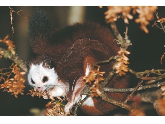
Invisible Ears for Flying Squirrel Ecological Research
In addition to biological and environmental monitoring, advances in digital technology have also brought benefits to ecological research at different levels. This is especially true for the research team of Guo-Jing Weng, Professor at the Institute of Wildlife Conservation, National Pingtung University of Science and Technology. His team set up recorders, with which, for the first time, they used the System for Intelligent Identification and Labeling of Biological Sounds (SILIC) to investigate the flying squirrel population. And they obtained some surprising results.
Weng explains: “We were commissioned by Taroko National Park Headquarters to carry out the Wild Mammal Species and Abundance Monitoring Program in the Mountain Area Surrounding the Dachingshu and Abandoned Mine Areas from 2022 to 2023. We conducted surveys on red and Formosan White-headed Flying Squirrel(Petaurista alborufus lena)and Formosan Giant Red Flying Squirrel(Petaurista philippensis grandis) near the Shakadang and Xoxos tribal villages.”
These flying squirrels are nocturnal, and are mostly active in the tree canopy. In the past, the traditional monitoring methods were to manually conduct onsite searches for flying squirrels via searchlights, or to set up automatic cameras for monitoring. However, these two methods are not only laborintensive, but make people work all night long. In addition, flying squirrels are not ground-walking animals, and are unlikely to leave enough footprints to trace their whereabouts, making it difficult to identify when and where they will appear. Therefore, manual inventories and camera imaging are not very effective.
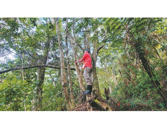
However, Weng and his team finally had a breakthrough: “the flying squirrels usually make some sounds when they move around, so we decided to use audio recordings. This not only allows us to record the sounds continuously, but also enables us to receive sounds from flying squirrels that are far away from us. This way is more efficient”. However, once the sounds are recorded, there is another challenge: “In the past, once we recorded eight hours of audio files, we had to then listen to all eight hours to figure out what each species sounded like. But now with the help of digital technology, the efficiency of monitoring and analysis has been greatly improved.”
The digital technology he’s referring to here is the SILIC system designed by the Biodiversity Research Institute. “In the sample area where flying squirrels are more likely to be found,” says Weng, “we spread out several recorders to collect audio files, then sent them to the SILIC system for identification. Based on these audio results, we learned how many Formosan White-headed Flying Squirrel and Formosan Giant Red Flying Squirrel were in this area. We also learned when they’re active, how often, what kinds of sounds their activities make, and more.”
However, since the data in the SILIC system is mainly collected from birds, the research team still had to examine the identification results from the SILIC system one by one for misidentifications. “The system would give us a possible flying squirrel result, and then we would further confirm it. On the whole, the identification accuracy is not bad! But the system still sometimes wrongly identifies the sound of insects chirping and frogs croaking, rain, or other animal sounds in the soundscape as the sound of a flying squirrel.”
Weng discusses how the system is implemented: “The accuracy of identification is mainly based on how much data we can provide. But by ‘how much’, I don’t mean the length of the audio file, but rather the clarity of the sound. If we provide more clear audio data as a basis for identification, the system will be more able to distinguish the flying squirrels’ sounds in later audio recordings.”
Based on their interpretations of the monitoring audio, combined with other data, Weng’s team deduced that the two species of flying squirrels in the area have a clearly more abundant sounds between 6:00pm and 10:00pm during the spring and fall seasons. At these times, the Formosan White-headed Flying Squirrel apparently cluster within the Daqingshui and Abandoned Mine Areas; while the Formosan Giant Red Flying Squirrel are more evenly distributed across the monitoring locations.
“The SILIC system is currently working with different academic institutions to enrich its sound database,” says Weng. “This is our first time trying this, but with the help of this system, our overall monitoring survey operating time has already been significantly streamlined. Therefore, we are looking forward to future digital audio technology developments that will enable us to do ecological monitoring research more deeply and more broadly.”