Challenges After Hualien Earthquake- Issues about Coexisting with Nature
Challenges After Hualien Earthquake
Issues about Coexisting with Nature
Article/ Hsiao-Chun Chen
Photo/ TNPH
Interviewees/ Min-Chun Lee, Officer, Planning and Management Section, Taroko National Park Headquarters
Lee-Chu Sun, Secretary, Taroko National Park Headquarters
Chun-Wei, Wang, Technical Specialist, Suhua Service Station, Taroko National Park Headquarters
Kuang-Chung Lee, Professor, Department of Natural Resources and Environmental Studies, National Dong Hwa University
April 3, 2024, 7:58:09 a.m. – At the peak of rush hour, when most people in Taiwan were hurrying to work and school, the island was struck by an earthquake measuring 7.2 on the Richter scale. The epicenter was in Shoufeng, Hualien. Taroko National Park—which once attracted countless tourists with its spectacular scenery of high mountains, amazing gorges, and towering boulders—was suddenly scarred by falling rocks. However, this stunning test by Teacher Earth has also made us reconsider how people and nature should share the resources of national parks and strive toward balance.
The Astonishing Earth Shocks
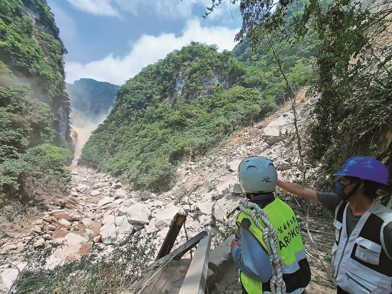
The seismic observation station closest to Taroko National Park is located in Heping Village, Xiulin Township, Hualien County, at what can be described as the park’s entrance. When the earthquake hit, it was measured as magnitude 6—second only to the maximum magnitude of the Central Weather Administration’s seismic intensity scale: strong earthquake, where people have difficulty standing. Min-Chun Lee, an officer of planning and management section of Taroko National Park Headquarters, had participated in Tianxiang Service Station’s rescue and handling efforts during the 418 Hualien Earthquake (a magnitude 7 earthquake that occurred in 2019). Knowing that his previous experience would be applicable to the current relief efforts, he volunteered to remain in the park and join the rescue operation. He immediately met up with his colleagues, and they entered the various trails under the jurisdiction of Suhua Service Station— Xiaozhuilu Trail, Dekalun Trail, and Shakadang Trail—in batches to conduct emergency rescue and preliminary disaster surveys.
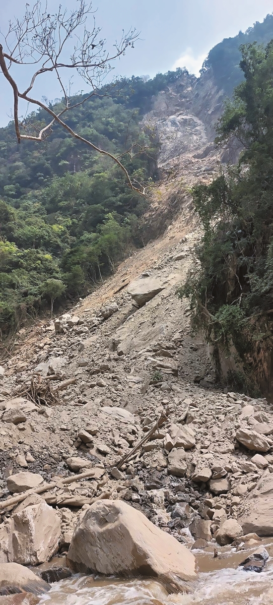
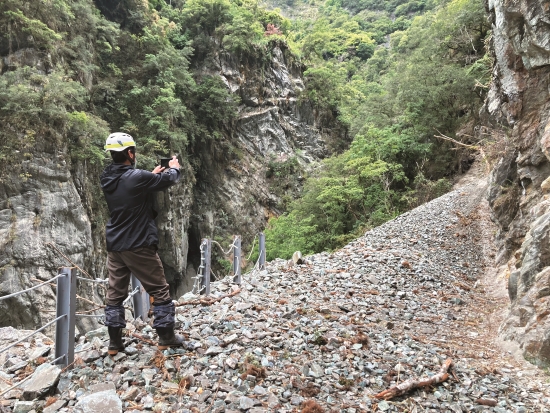
Min-Chun Lee recalled that when he entered Shakadang Trail for the first time after the earthquake, the blue water of the river, the colorful marble patterns of the riverbed, and the meandering trail along the stream were all gone. In particular, the marble and gneiss that had been polished smooth and shiny by the rushing river were buried under rocks that had fallen from the heights during the earthquake. The first group of search and rescue workers even experienced moments when the landscape changed forever. “Especially when we were walking along the waterway into the deeper section of the trail to begin the rescue. As we passed the 0.45-kilometer marker, we first heard a low groan, then we saw falling rocks start to loosen up, and soon afterward, the entire 80 meter-high mountain wall, along with a large number of falling rocks, collapsed.”
Moments before disaster struck, Lee and his team vigorously waved to Sheng-Yan Yu, a park ranger who had taken the trail to rendezvous with the search and rescue team, warning him to retreat and find a safe place to take cover. Recalling this scene, Lee still has a lingering pang of fear. “Luckily, he eventually understood our gestures to run backward, and he immediately left the landslide area.”
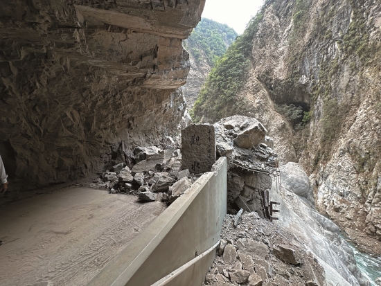
At that instant, a waterfall of sand and dust rushed toward the stream on the trail that was previously almost untouched by rockfalls. The Shakadang Trail is 4.1 kilometers long. The guardrails and viewing platforms along the way were destroyed by a large amount of earth and rocks. The entire valley was almost completely buried. The landscape were completely different from those in the past.
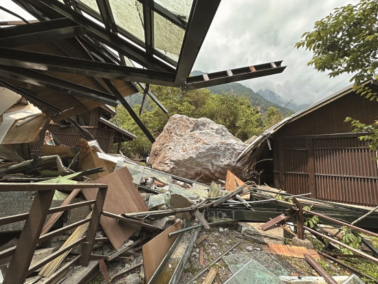
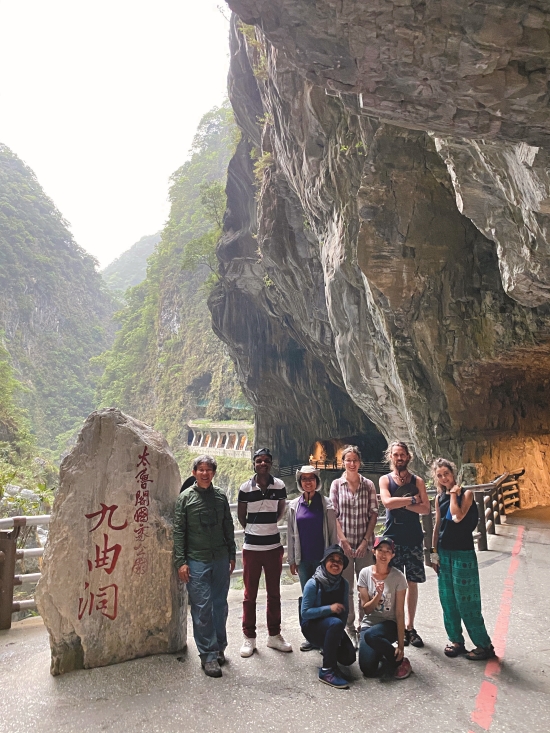
“In the past, when there was an earthquake or a typhoon, the impacts were mostly localized. This is the worst disaster I have ever seen in over 30 years of working at Taroko,” said Lee-Chu Sun, secretary of Taroko National Park Headquarters, counting the areas damaged by the disaster. “Even after the earthquake, crustal movements remain frequent; therefore, with the exception of the immediate rescue operations for stranded tourists, for safety reasons we are not yet able to really enter each disaster area. We can only ask park rangers to carry out preliminary inspections of the relatively safe areas and give an overview of the affected areas throughout the park. So far, we have learned that from the northeastern Daqingshui recreation area south to Huide, Chongde, Taroco Terrace, Taroco Arch, Changchun Shrine, Buluowan, Yanzikou , Jiuqudong to the Baiyang Trail in Tianxiang, it can be concluded that the most exquisite section of the gorges and the magnificent Daqingshui Cliffs have all suffered damage to their natural landscapes or recreational facilities, and the scope of the damage is unprecedented and unparalleled.”
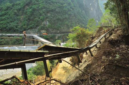
Although the open-cut tunnels effectively performed their function of resisting falling rocks and providing refuge during the earthquake, the park also has many naturally formed trails, such as Shakadang Trail, Lushui Trail, and Zhuilu Old Trail. Limited by environmental factors, these trails could only serve as refuge or protection facilities to a certain extent. These were the areas that suffered serious damage from the earthquake, and where most of the tourists were stranded.
Emergency Response Tasks of Taroko National Park Headquarters
1、Set up a Disaster Response Center, with the head of the Headquarters and all first-level supervisors stationed there.
2、Publish announcements on the park’s website in Chinese, English, and Japanese prohibiting all tourists from entering the park.
3、Deploy staff to inspect and report on the disaster conditions and close the entrances to the trails.
4、 Continue to cooperate with rescue teams to carry out the rescue and temporary relocation of tourists.
5、Monitor the impact of weather changes on disaster relief and the environment.
Race against Time to Rescue Stranded Tourists
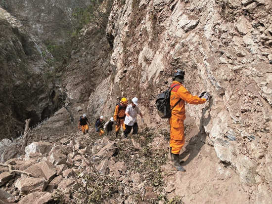
Chun-Wei, Wang, a technical specialist at Suhua Service Station, was on her way to work when the earthquake hit. She was near the East–West Cross Island Highway Arch when the road to her office was temporarily blocked by falling rocks. Her only option was to pull over to the side of the road and wait for it to be cleared. Fortunately, the mobile communication system was not damaged by the earthquake that day, and communications remained smooth, so she began to contact her colleagues at the scene to confirm the disaster and rescue operations. Prior to the arrival of fire and emergency personnel, the main search and rescue force, which went deep into the trails to rescue stranded travelers, comprised the park rangers who patrolled the trails daily and their colleagues who manned the service stations.
Wang recalled that when park rangers Cheng-Hua, Lo and Min-Chun, Lee rescued the first group tourists from the Xiaozhuilu Trail near Suhua Service Station, the mother and daughter had different degrees of injuries and it was determined that one of them needed to be sent to the hospital immediately. Wang was still parked at Taroko Arch when she saw the engineers responsible for clearing the highway and the ambulance arrive. After entering the park with the ambulance, she not only assisted the mother and daughter in receiving medical treatment, more importantly, noting that most of her colleagues had left the station to assist with rescue duties, she took over dispatch responsibilities for the rapid influx of demands for support from the office.
In addition to fielding a constant influx of phone calls, staff at Taroko National Park Headquarters and other service stations immediately estimated the number of visitors who had entered the trails based on parking lot monitors and reports from on-site cleaning staff and park rangers. In the case of Shakadang Trail which was severely damaged, “The rescue operation took approximately 28 hours total.” Min-Chun, Lee recalled that he, park rangers Cheng-Hua, Lo and Cheng-Lung, Chiang entered Shakadang Trail from the western section of Xiaozhuilu Trail; Sheng-Yen, Yu met up with them, and they joined forces to conduct the rescue.
Because the earthquake occurred early in the morning, there were not many tourists and vendors on the trail. Prior to the arrival of the search and rescue team, 14 people, including cleaning staff from the park, had arrived at Wujianwu, where local residents sell food and handicrafts. While waiting for the rescue team to arrive, vendors offered food and drinks to keep everyone going. “To conserve cell phone battery, I asked them to assign a representative to keep in touch with us by text message.”
As most of the trails had been practically destroyed by rockfalls, and continuous rockfalls were still occurring along the trails, the search and rescue team was forced to trek through the river, which required constant backtracking and changing of route. They needed tribal residents who were more familiar with the local terrain to lead the way; therefore, they retreated to the service station, regrouped, and joined up with the firefighting team to enter the trail. Considering that it was getting dark, In the late afternoon, local residents, firefighters, and cleaning staff brought nine foreign tourists off the trail, leaving two foreign tourists, who were obviously in poor physical condition, to wait in Wujianwu.
“Two foreign tourists had told us that the coffee shop owner who had been reported missing in the morning was still trapped on a deep part of the trail. She had been making coffee at the time of the earthquake, and could be in serious danger.” Min Chun, Lee and his team, together with Jung-Hua Chen, the Squad Leader of the Sub-Taroko Division, Ninth Division, The Seventh Special Police Corps, National Police Agency, continued to search the area with the guidance of local residents. Finally, by following the scent of gas, they found the seriously injured resident at the 2.4-kilometer mark of the trail.
“Every person who came out from the trail, their skin was covered with a thick layer of dust, and their whole body turned black.” This was the scene that left the greatest impression on Chun-Wei Wang during the search and rescue process. Meanwhile, Cheng-Hua, Lo remained on Shakadang Trail to watch over the injured. Worried that the injured tourists might be hit by falling rocks, he used a jacket left by his coworkers to withstand the frigid mountain temperature and didn't close his eyes for the entire night. It wasn’t until about 1:30 p.m. the next day, when the injured were evacuated from the area, that he stepped off the trail on his own and returned to the office to continue to standby for rescue.
Response Approaches after the Earthquake
Although the earthquake may be a once-in-a lifetime natural disaster for most people, for the environment, it is one of the important natural forces that shape the magnificent scenery of Taroko.“When I was in college, I went on a field trip with my teachers and classmates to the newly established Taroko National Park. Back then, it was still possible to walk under Cimu Bridge, so we jumped over big and small rocks one after another to trace the stream. We thought it was unbelievable how nature could have piled up so many big rocks in the riverbed.” Kuang-Chung, Lee, a professor at the Department of Natural Resources and Environmental Studies at National Dong Hwa University, recalled his first visit to the confluence of Liwu River and Laoxi River over 30 years ago, when he experienced the gorge’s gigantic rocks firsthand and was moved by the beauty of the fast-flowing waters.
The formation of Taroko Gorge is attributed to orogenic movement caused by the collision of the Philippine Sea Plate with the continental plate, which continuously uplifted the marble layer at the bottom of the sea. Additionally, Taiwan is located in the subtropical zone, and the eastern windward side of the island is hot and rainy in the summer with many typhoons. The abundant rainfall in the catchment area creates rapid streams that merge into the Liwu River, which flows through the delicate and water-soluble marble at great speed. The constant high speed downward cut of the streams is like an extremely powerful, sharp blade, causing intense erosion. As a result of the interaction between the long-term uplifting of the earth’s crust and the downcutting of the streams, a V-shaped marvel with vertical walls more than 1,000 meters deep has appeared between the two sides of the ravine and the more than 10 kilometers of rushing streams.
“Previously, we could only speculate on the impact of earthquakes through theories and hypotheses. It was only after the 403 earthquake that we realized it was possible for earthquakes to trigger landslides of such a massive scale and form large areas of falling rocks and avalanches in Taroko National Park,” said Lee. He used the popular walking trail at the entrance of Chongde Tunnel, next to the Qingshui Cliffs, as an example. “The landslides caused by the earthquake made us realize that the trail leading to the beach was also built following huge avalanches. Moreover, the impact of earthquakes and flood on the topography and geomorphology of Taroko may be far greater than we previously believed, overturning the original assumption that Liwu River Gorge was formed over millions of years. It may have reached its current scale in only a few tens of thousands of years.”
According to Lee, this also precisely illustrates the challenges faced by the Central Cross-Island Highway. After the highway opened, Taroko’s unique beauty became more widely known and more convenient for everyone to access and appreciate. However, this arduous project, which initially emphasized the idea that “man can conquer nature,” has collapsed and been rebuilt due to earthquakes and windstorms many times in a short span of just 60 to 70 years. Worse still, because some sections of the roadbed are close to the riverbed, after multiple landslides, whole sections have been destroyed by falling rocks or eroded, hollowed out, and washed away by heavy rains. Continuous reconstruction is very difficult, so the road must be shut down and diverted. In the case of some roads and trails, the surrounding slopes have reached the point where repairs are impossible, and even after exhausting all methods, the falling rocks cannot be stopped—the only alternative is to replace the roads by constructing tunnels to ensure the safety of pedestrians and vehicles traveling through the area. It is hoped that in the future, disasters can be reduced by minimizing the chances of vehicles passing through the slopes, building longer tunnels, and installing park buses and intelligent monitoring systems.
In fact, this is one of the measures that Taroko National Park Headquarters is actively planning. After a 2010 rockfall incident at the Tunnel of Nine Turns resulted in casualties, the headquarters decided to adopt an eco-engineering method that coexists with the environment. This included the extension of the Jiuqudong Tunnel to the trailhead and the construction of three “eco-scenic open-cut tunnels” that provide protection against rockfalls as well as scenic views.
From Reconstruction to Coexistence with Nature
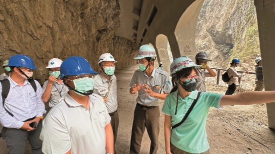
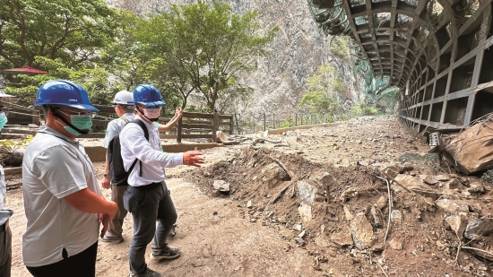
After the earthquake, the National Park Service deployed additional manpower to assist Taroko National Park Headquarters in actively investigating and reconstructing the disaster area, instituting the principle of reopening the park in phases and zones. According to Lee-Chu, Sun, as for the overall landform changes that have occurred, the headquarters has commissioned a consulting firm to conduct investigation and safety assessment. After the earth’s crustal movement has calmed down a bit, drones will be deployed on the trails and into the depths of the disaster areas to take satellite images of the long-term sampling points. This will enable headquarters to identify the direction of future reconstruction and compose strategies for reopening the areas.
For areas that are relatively safe, including Taroko Terrace, Changchun Shrine, Buluowan, Tianxiang, the headquarters is scheduled to reopen in stages from 2024 until the end of 2025. As for the more seriously damaged areas such as the Swallow Grotto Trail, Shakadang Trail, the reconstruction program still needs to be planned in detail, and is initially estimated to be completed by 2031.
Nevertheless, perhaps due to the shock of the wounds on the land, the typical cries for the headquarters to be reopened as soon as possible after the disaster have been less intense this time around. Through photos depicting the actual damage, more and more people recognize the concept that, “The earth needs to recuperate in order to minimize the chance of future backlash,”
and look forward to reestablishing a relationship with Taroko National Park, and sharing the mountain and forest resources in a sustainable way.
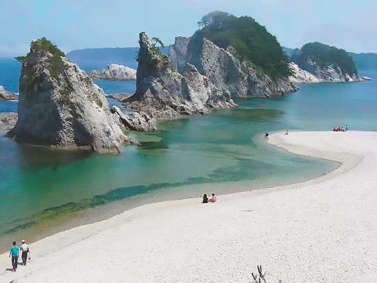
In the long process of land restoration and park reconstruction, the needs and participation of local residents must also be considered. Kuang Chung, Lee has always been committed to the promotion of human-maintained foothills and coastlines (satoyama and satoumi initiatives). He believes that the earthquake is a turning point in the development of Hualien’s overall industries and that Sanriku Fukko National Park, which was set up in the aftermath of the 311 Great East Japan Earthquake, is a model they can reference.
“This coastal park is about 250 kilometers long, stretching from Aomori and Iwate in the north to Miyagi Prefecture in the south connecting protected areas, scenic areas and rural areas. Whether through restoration or reconstruction, the traditional lifestyle, culture, crafts, products, and disaster prevention issues of the original inhabitants within the park area should be incorporated into the park; in other | Sanriku Renaissance National Park/ Provided by Junpei Satoh(來源: https://commons.wikimedia.org/wiki/File:Jyoudogahama.jpg) 國家公園 words, we must achieve ‘coexistence between man and nature’”, explained Kuang-Chung, Lee.
A Pioneering Native Seed Ball Expansion Program
The earthquake created unparalleled wounds in Taroko, resulting in more numerous and steeper slopes, and leaving many with a profound feeling that “The earth has become more rugged!” However, new challenges and opportunities have grown from these cracks in the earth. Just as the cliffs near Changchun Shrine, which suffered a major collapse in 1987, are now full of life after more than three decades, Lee-Chu, Sun believes that “Time will bring about nature’s self-healing power!”
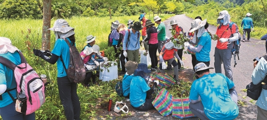
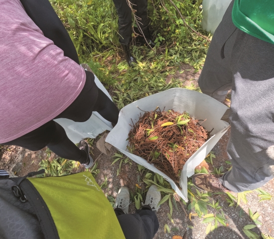
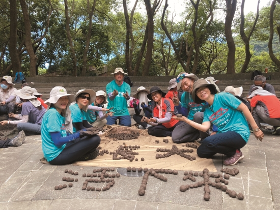
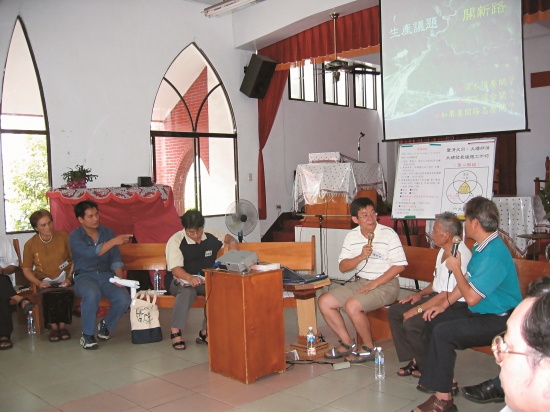
However, in order to prevent exotic species, such as the highly prolific Leucaena leucocephala and Mikania micrantha, from invading the exposed rock strata and collapsed land while Taroko is recuperating, Taroko National Park Headquarters also cooperated with Hualien’s Tzu-Chi University. Under the leadership of Professors Yie-Ru, Chiu and Mu-Lin, Chang, students and park volunteers were instructed to search the southern district of Hualien for five types of native plant seeds: Callicarpa formosana, Boehmeria densiflora, Boehmeria wattersii, Buddleja asiatica, and Thysanolaena latifolia. The seeds were then dried, mixed with the soil, and pinched in the palm of their hands to create meatball-sized seed balls.
In early July, Taroko National Park Headquarters and Mu-Lin, Chang led volunteers to sprinkle and catapult tens of millions of native Taroko seeds onto the collapsed land near the entrance of Chongde Tunnel, which had been seriously damaged. Sun Lee-chu emphasized that the seed ball collection and production program is still ongoing. In order to strengthen the restoration of mountains and forests, in the future, they plan to utilize drones for large-scale seed distribution during the most suitable planting seasons. The seed balls will be scattered in collapsed and exposed rocky areas, overcoming the challenge of strong winds in the gorge, and accelerating and expanding the area for seed ball proliferation.