
Digital Recreation: Fun at Your Fingertips!-Hybrid Event for Borderless National Park
Digital Recreation: Fun at Your Fingertips!
Hybrid Event to Borderless National Park
Article/ Chih-Ya Cheng
In this era where everyone has a device in hand, new media is sprouting up like bamboo shoots after a spring rain. Auditory and visual expressions and stimuli have liberated knowledge acquisition from the traditional constraints of written symbols, broadening the definition of “reading” as our sensory perceptions expand.
Following up on the cover story from the Summer 2024 issue, digital technology has not only significantly supported research and investigation ef forts related to the conservation and restoration of national park ecosystems; it also sparked the creativity of staff at various national park headquarters. Digital technology has been ingeniously utilized to seamlessly integrate recreational activities with educational promotion. This integration has captivated the public through intellectual activities such as real-life puzzles, adventure stories, cultural walks, and treasure hunts. Utilizing diverse channels, these initiatives guide visitors from the virtual online world into the tangible, natural world.
Among these digital tools, real-time updating and highly interactive apps have become powerful tools for interpretation and educational promotion. Immersive VR and 3D models break physical and geographical barriers, allowing the public to explore hidden realms. Moreover, vibrant and flexible thematic short videos and podcasts instantly draw more people into the foundational ecological knowledge systems, unveiling the biodiversity treasures housed within each national park.
Explore the World in Your Palm
Interviewees/ Wei-Jen, Chang, Technical Specialist, Recreation Service Section, Shei-Pa National Park Headquarters
Hsiao-Wan Chang, Technical Specialist, Interpretation and Education Section, Yangmingshan National Park Headquarters
Chen-Ya, Huang, Officer, Interpretation and Education Section, Taijiang National Park Headquarters
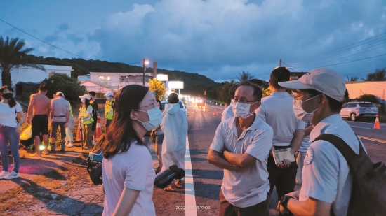
As the pandemic restrictions ease and domestic tourism gradually rebounds, more and more people are seeking recreation in the mountains and by the sea. How can we ensure that the public enjoys these beautiful landscapes safely while also gaining new knowledge? Shei-Pa National Park Headquarters, Yangmingshan National Park Headquarters, and Taijiang National Park Headquarters have all initiated the design and development of user-friendly apps that are easy to download and operate. These apps incorporate crucial practical features, such as geolocation coordinates and offline map tutorials, while also integrating new cultural and ecological insights. These modern, handheld wonders are not only enriching and entertaining but also serve the purpose of educational outreach. Through the small windows on their screens, visitors can gain a more comprehensive understanding of every corner of the national parks, ensuring that each journey is safe, enjoyable, and memorable.
Open the APP, Keep You Safe
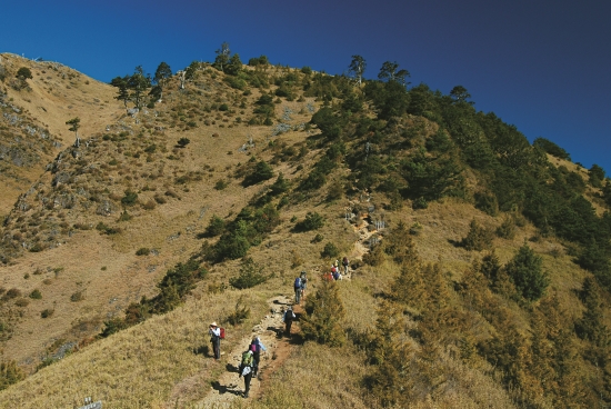
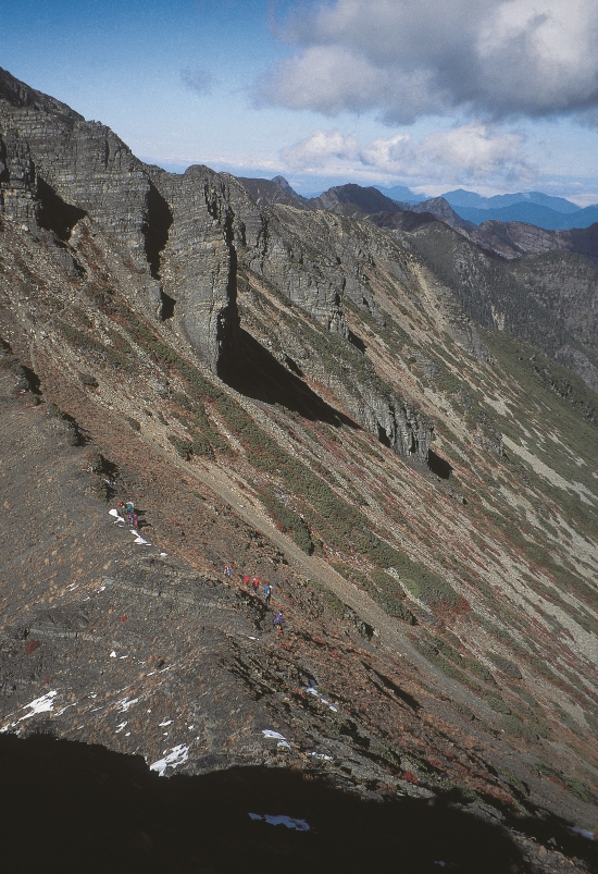
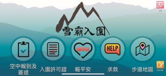
Taiwan’s “Hundred Peaks” are renowned far and wide, drawing an ever-increasing number of domestic and international visitors who are eager to experience the subtropical high altitude allure of these ancient landscapes. Within Shei-Pa National Park, popular entry points for the general public include Guanwu, Wuling, Xuejian, and Wenshui. Despite the breathtaking beauty of these majestic mountains, they can often resemble an elusive labyrinth, with the potential to lead travelers astray at any moment. Many accidents occur due to unfamiliarity with the terrain, resulting in individuals inadvertently wandering into the wilderness—which can lead to fatal falls or exposure due to lack of shelter. To mitigate such risks, Shei-Pa National Park Headquarters developed the Shei-Pa Entrance App, aimed at reducing the incidence of mountain-related accidents.
Wei-Jen Chang, a recreation technical specialist of Recreation Service Section at Shei-Pa National Park Headquarters, expounded upon the app’s development. The initial planning stages contemplated a fusion of navigation functions, electronic maps, and corresponding real-world environmental photos to help users identify their exact location and determine whether they had deviated from the trail. However, it was discovered that the extensive data required for such maps necessitated high hardware specifications and led to significant battery consumption, which discouraging widespread download of the app by members of the public. As a result, an alternative approach was chosen, focusing on the most basic yet crucial need for reducing mountain accident risks: coordinate positioning via SMS.
“Initially, we introduced two main functions: SOS and offline maps. Experienced hikers can directly download and use the park’s offline maps, whereas newcomers who are unfamiliar with map navigation can use the one-click SOS function. This sends a coordinate positioning text message, informing family members or rescue units of the user’s location and general area,” said Wei-Jen Chang. He highlighted that the advantage of SMS lies in its ability to retain coordinate information even in areas with no cellular signal. When the hiker moves to a location with a weak signal, the system can automatically send the stored message without requiring repeated connection attempts.
Subsequently, to further enhance user convenience, additional features such as Mark Safe and Aerial Reporting were introduced. Chang elaborated, “Our interface design prioritizes intuitive use. Users needing to mark themselves safe or send an SOS can simply select the relevant option without wasting time searching through multiple layers of menus or worrying about getting confused or being unable to see.”
Chang also mentioned several practical features under development for future updates, including real-time weather updates for the park, notifications about park openings and closures, and safety tips for hiking. These enhancements aim to provide essential information quickly, fostering a closer connection with Shei-Pa National Park and ensuring that every visit to the mountains is a fulfilling, and memorable experience.
An Ecological Gem Hunt in Full Swing
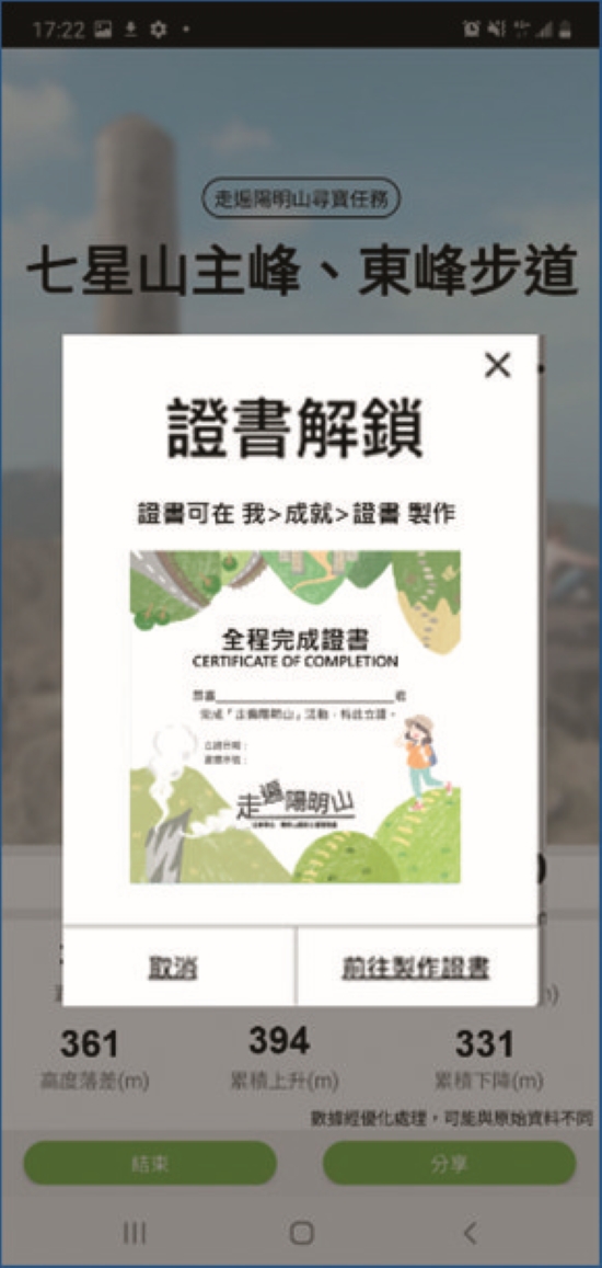
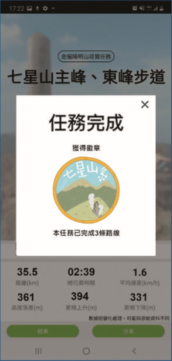
In response to increased reports of lost hikers during the pandemic, Yangmingshan National Park Headquarters launched the Explore Yangmingshan App Treasure Hunt in 2023. This initiative aimed to encourage visitors to explore the equally scenic but less frequented trails within the park, allowing them to appreciate the beauty of Yangmingshan National Park from different perspectives and helping them become familiar with offline maps. Technical Specialist, Interpretation and Education Section, Yangmingshan National Park Headquarters
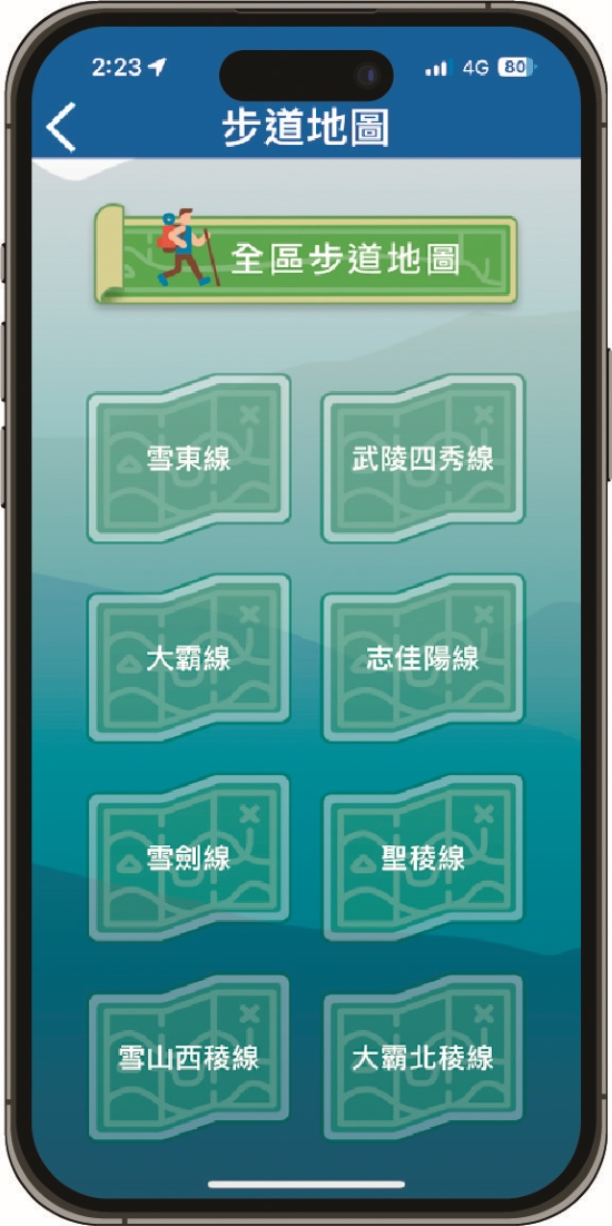
Hsiao-Wan Chang, an technical specialist of Interpretation and Education Section at Yangmingshan National Park Headquarters, noticed the popularity of the Hiking Notes app, which also promotes outdoor activities. After several consensus meetings, both parties quickly integrated the trending “treasure hunt” concept into the existing Hiking Notes app. They divided the hiking routes into four systems comprising 16 trails to create the Explore Yangmingshan App Treasure Hunt. The game featured trendy illustration design, clearly presenting the trail systems and the characteristics of highlighted species.
“Organizing the preliminary data was crucial to quickly focus on the most engaging and easily understandable information for the public. We conducted field surveys on each trail to check for necessary maintenance and estimated the time required, ensuring a smooth treasure hunt experience for participants,” Chang explained with a smile. “We strategically ‘hid’ virtual ecological gems based on previous data analysis, ensuring that hikers would find a gem every 500 to 1000 meters. This distance is neither too short to be boring nor too long to be discouraging, maintaining a balance that keeps participants motivated to continue.”
The app’s popularity was evident from the start. Within just 9 months after the game’s release, over 2000 visitors had completed the full certification. Even after the event concluded, it remained a hot topic among hiking enthusiasts, underscoring its widespread appeal. For those who missed out, Chang offered reassurance, In the recreation information option of the official website of Yangmingshan National Park, there is still a "Trail Exploration" page that can be searched. It also compiles hiking safety knowledge and most importantly trail maps and route maps. Everyone may evaluate physical fitness, bring the equipment, and start another hiking challenge that is completely your own!


Decrypts the Coastal Salt Fields with a Mystery Micro-novel
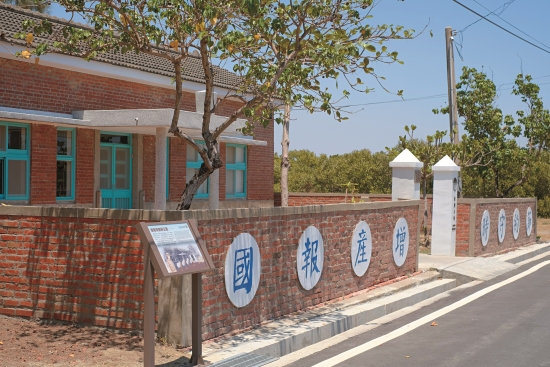
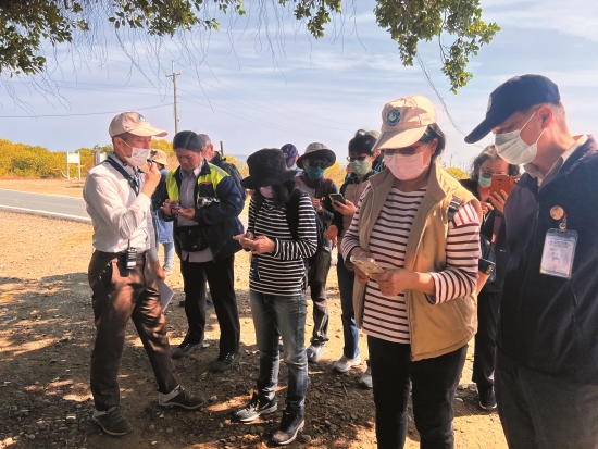
Nestled in Tainan, a city with a history spanning over four centuries, Taijiang National Park boasts a unique blend of cultural landmarks and natural ecology. How can one quickly comprehend the history of this extensive, centuries-old landscape? Taijiang National Park Headquarters has developed the one-of-a-kind Anshun Salt Field Outdoor Mystery Game App. Akin to a time-traveling wormhole, the app guides the public on a linear path back to the glorious era of Anshun Salt Field.
Chen-Ya Huang, an officer of Interpretation and Education Section at Taijiang National Park Headquarters, provided an overview:
During the Japanese colonial period, a distinctive industrial village centered around the salt fields was established near the coast of Anping. Post-war, due to government policies and environmental changes, the salt field structures and areas either remained in use or were repurposed, embodying significant local industrial history. She explained, “We aim to draw attention to this historic area. Despite the presence of the Anshun Salt Story Museum and guided tours by staff, the stories beyond the museum need a more engaging approach than simple explanatory signs to attract public interaction and encourage self exploration of the site.” In other words, integrating the popular concept of cultural walks into a digital game enhances visitors’ autonomy, motivating them to continuously explore various parts of the salt field.
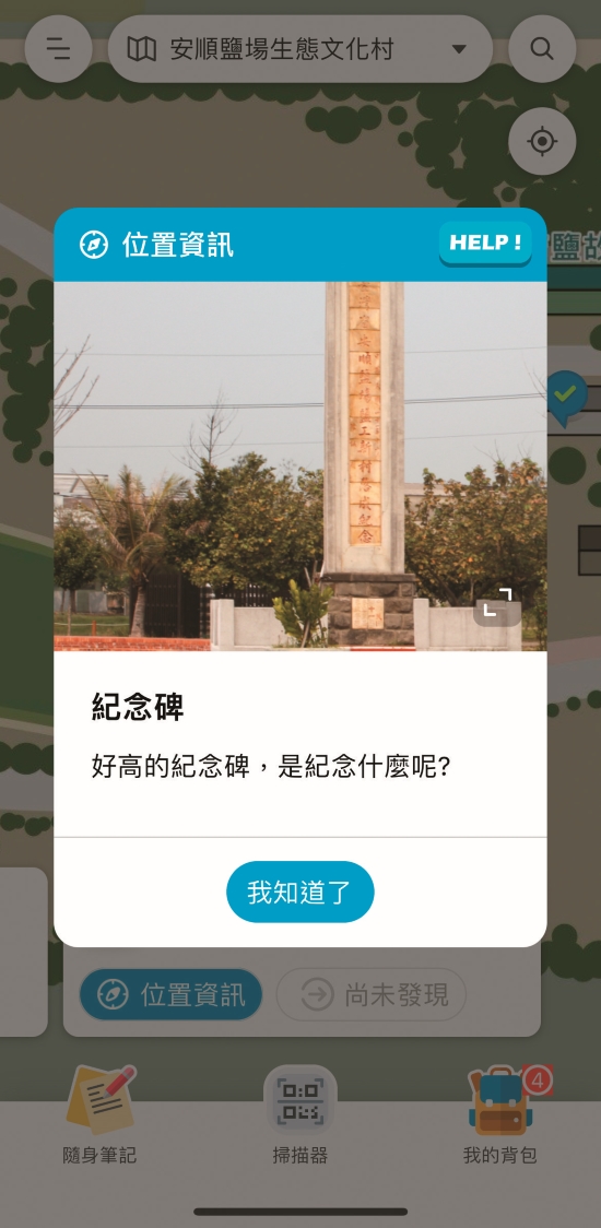
“However,” Huang noted, “the fierce Tainan sun makes it difficult for people to stay outdoors for long periods. Hence, from the initial planning stage, we decisively abandoned time-consuming activities such as treasure hunts or item collection. Instead, we adopted real-world positioning and riddles, combined with a fixed route model.” Along this predefined route, there are five checkpoints, and players must solve one puzzle to proceed to the next. The checkpoints are not causally linked, focusing instead on encouraging exploration of buildings and surrounding environments to understand Anshun Salt Field’s historical context from a macro perspective.
Another feature is that all clues are hidden on site, with answers closely tied to the historical stories behind the buildings and locations. Huang shared, “We found that many visitors learned about the cultural significance of the salt fields through the game—it contained information they previously didn’t know. They often return with friends to experience it again. Also, children usually solve the puzzles faster than adults, quickly deducing the answers.” This phenomenon highlights that while technology stems from human nature, even digital games require us to put aside our habit of online searching. By immersing ourselves in the physical landscape, we can spark broader imagination and discover the ultimate answers.


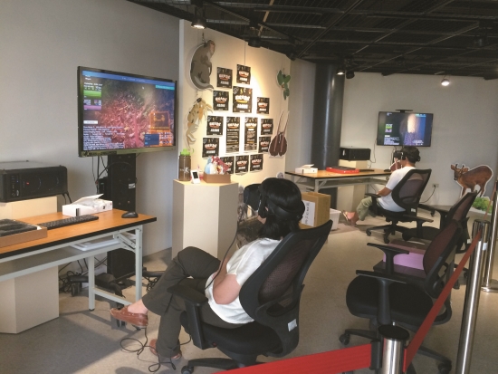
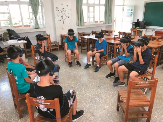
Immersive VR Experiences Bring Nature to Life
Interviewees/Ya-Ting, Huang, Technical Specialist, Conservation and Interpretation Section, National Nature Park Headquarters
Wei-Hsiang Chao, Project Manager, Funique
Yi-Tien, Su, Technical Project Manager, Funique Specialist, Interpretation and Education Section, Marine National Park Headquarters
Hung-Chiao, Chen, Technical Specialist, Conservation and Research Section, Kinmen National Park Headquarters
“Now, let’s navigate around the moon and head toward Earth. Hold on tight, everyone!” In the VR mini-adventure film, created by Shoushan National Nature Park Headquarters in collaboration with private organizations, an alien pilot protagonist takes families on a journey exploring symbiotic relationships in nature, delving into the mysterious limestone caves of Shoushan. Similarly, Marine National Park Headquarters has produced a panoramic film with land, sea, and air perspectives, showcasing the ecological beauty of the Four Southern Islands of Penghu in unparalleled detail. Meanwhile, Kinmen National Park Headquarters’ 3D models of battlefield sites vividly bring history to life, thrilling military enthusiasts and captivating the general public.
These innovative endeavors allow the public to experience the powerful synergy of digital technology, ecological knowledge, and interactive gaming, emphasizing the multidimensional allure of these experiences. Under the comprehensive 3D panoramas, the national parks appear closer than ever, bringing distant natural wonders right to the viewer’s doorstep.

Embracing Nature : Exploring the Microscopic World
Ya-Ting Huang, Technical Specialist at National Nature Park Headquarters’ Conservation and Interpretation Section shared the origins of the VR micro-adventure project, which was initiated by their collaborative partner, Funique. They proactively contacted us, hoping to collaborate with Shoushan National Nature Park. They wanted to use their newly developed macro photography and 360-degree environmental filming technology based on Shoushan’s natural landscapes and organisms."
How did this unique focus on specific themes and species come about in the VR micro-adventure film? Wei-Hsiang Chao, Project Manager of Funique explained, “Initially, while reviewing materials, we discovered that many animals and plants inhabit the limestone caves of Shoushan, which is a distinctive feature of the local biological landscape. We wanted the film to encompass animals, plants, and their habitats. Coincidentally, Ya-Ting Huang introduced the idea that in some unique terrains, organisms live in mutualistic relationships. Naturally, the theme of ‘symbiosis’ emerged.”
Huang agreed that this theme was not only novel but would also require significant effort and time to produce. “Maximizing the ‘macro’ aspect was a key focus in production. We held multiple discussions to identify species worth observing up close and pondered what significance and new knowledge could be derived from such close observation.” For instance, Shoushan’s famous limestone caves are generally not fully open to the public due to safety and ecological preservation reasons. Visitors wishing to glimpse the mysterious scenery need to apply in advance, and even then, the tours are often limited by pathways and weather conditions. “The film can preserve the most precious environmental and ecological images, allowing viewers to explore freely, breaking the constraints of time, space, and physical endurance,” Wei-Hsiang Chao added.
“This film is designed as a regional educational piece. Having it be composed entirely of real life imagery could make it monotonous, so we included adventurous fictional elements to keep it engaging. Some scenes were shot with a narrow focus or with the panoramic view deliberately limited to within 170 degrees to prevent viewers from being distracted by less important background elements,” Chao explained. “This approach addresseed two issues: the weight of the VR headset, which can be physically taxing, and the potential for eye strain from detailed viewing. Hence, the ideal VR film length is around 10 to 15 minutes.”
Huang recalled, “Each step of the photography process was extremely time-consuming and physically demanding. For example, during cave filming, one person had to enter an environment half their height and spend the entire day—8 to 10 hours—crouching, lying, or sitting to capture all the intricate details and angles. The team spent over 10 days in the field to complete just a short 2-minute cut."
Entering Secret Realms thourgh Panoramic 3D VR
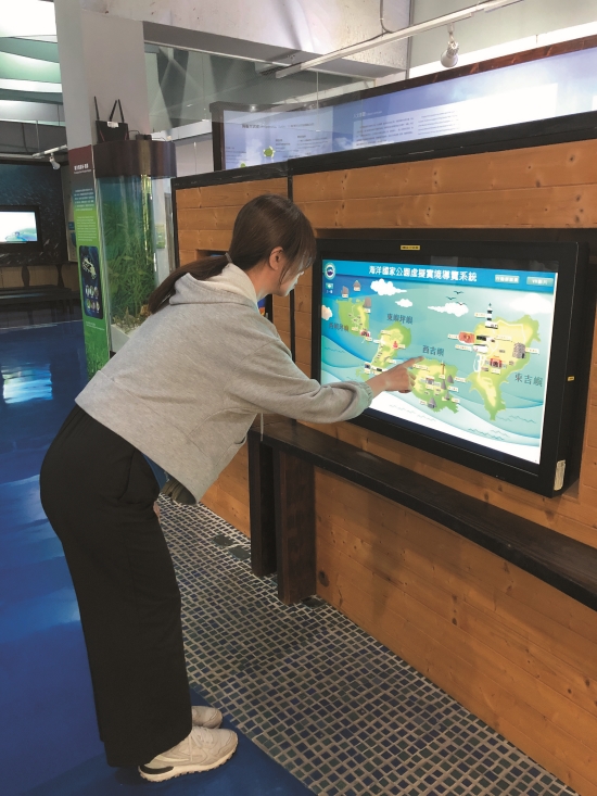
In addition to Shoushan National Nature Park, South Penghu Marine National Park has also invested considerable time, manpower, and resources in constructing a panoramic VR system. Yi-Tien, Su, technical specialist of Interpretation and Education Section at Marine National Park Headquarters, explained, “Since 2019, we have progressively completed eight 360-degree panoramic 3D VR short films on land and in the underwater areas of the four islands. Over the past 2 years. from 2022, we’ve integrated these films with mobile interpreters and 3D models to form a comprehensive VR system, which is currently available in the lobby of headquarters.”
The development of this panoramic VR system aims to provide a full view of the park’s stunning scenery for visitors who cannot dive or do not yet plan to visit the South Penghu Four Islands. “For example, the Blue Hole in the South Sea Columnar Basalt Nature Reserve is a famous spot restricted by cultural heritage preservation laws, and entry without permission is prohibited. So, we collaborated with the National Museum of Natural Science to film the Blue Hole’s landscape from aerial, ground, and underwater perspectives. When visitors put on the VR headset, it’s as if they are physically there,” Su added. “Additionally, most tourists visit the South Penghu Four Islands briefly, and they miss out on many details. A comprehensive panoramic VR system allows for a deeper understanding of Marine National Park’s ecological environment.”

Creating VR content is a complex and costly process, from equipment to production. Consequently, the current promotion of VR experiences is limited to specific activities held intermittently in the lobby of Magong Visitor Center, offering the public a chance to experience it. Post-pandemic, Marine National Park Headquarters has shifted from on-site registration to promoting VR during special educational events such as school visits and teacher workshops, inviting participants to experience it firsthand.
Su noted, “During the testing phase, we realized there were still parts that need supplementary shooting or expansion. In the future, we might have to regroup and create new material to continuously update the content. This requires long-term planning.” Ya-Ting Huang echoed similar sentiments, “Visitors often ask if there will be sequels. The Headquarters is certainly willing, but producing new content requires professional teams, sufficient funding, and time.” Judging by the VR film results from both headquarters, the public eagerly anticipates further developments and sequels in the future.


National Park Highlights
Exploring the 3D World: Delving into Military Strongholds
Hung-Chiao,Chen a technical specialist of Conservation and Research Section at Kinmen National Park Headquarters, previously explained how digital technology is integrated into geomorphological monitoring projects. Today, she eagerly shared a new digital edutainment proposal. “Kinmen National Park has a unique historical context. Due to its strategic importance, the location was previously sealed off, making it difficult for outsiders to observe and understand the environment. Before fully opening to the public, we can introduce the historical military sites through 3D models. This provides a safe way for people to explore the observation posts, radar stations, and bunkers of this globally unrivaled military landscape.
“We initially focused on ten significant military historical sites. Constructing these models required extensive aerial photographs, historical documents, and on-site measurements combined with laser scanning to create precise three dimensional images. We then applied realistic textures and rendered the images to accurately represent the underground tunnels’ depth, width, length, and spatial distribution. This information is difficult to fully grasp, even when walking through the tunnels.”
These realistic models serve as a digital record and a detailed academic reference. However, the primary goal of this pioneering project is to enable the public to gain a comprehensive understanding of these sites. “After completing the models, we uploaded on the YouTube, and build a virtual reality exhibition to allow the public to travel across time and space to visit the Lieyu Visitor Center in Jiugong Tunnel. The ten significant military historical sites were uploaded on SketchFab, which is a site that’s popular with model enthusiasts and experts. At the same time, videos and models are also embedded into headquarter’s website to enrich recreational information on military sites.
In addition to navigating the 3D models using a computer mouse for horizontal and vertical movement, AR and VR functionalities are also available. Even without VR equipment at home, switching to AR mode on a smartphone creates an immersive experience, as if being transported into the military sites. “To enhance the interactive experience, we also filmed guided tours and hosted online exhibitions and workshops. These guided tours and online exhibitions were not just for promotion but also to provide historical context and explanations while users interact with the models. This synchronized audiovisual information delivery makes the experience more immersive.”
3D model construction and research and promotion plan of historical military sites, KNPH, 2023


Nature’s Whisper Day and Night
Interviewees/ Ke, Lee, Senior Broadcaster
Chiung-Yao, Lin, Senior Interpreter, Interpretation and Education Section, Kenting National Park Headquarters
Kenting National Park, with its majestic mountain and sea vistas, showcases a multitude of natural faces and vibrant lifeforms throughout the changing seasons. This ever-transforming natural world attracts countless visitors each year. As Taiwan’s first national park, Kenting National Park Headquarters has consistently been at the forefront of integrating educational outreach with emerging media forms. In recent years, the park has embraced innovative communication methods, such as producing podcasts and mobile video guides to reach and engage with younger audiences. These efforts aim to break through conventional boundaries and immerse people in ecological and environmental issues through both visual and auditory experiences.


Listening to Nature Anytime, Anywhere
Kenting National Park Headquarters has long collaborated with seasoned broadcaster Ke, Lee, who reflected on how this partnership has led her to immerse herself in environmental issues for over 35 years. As digital media continues to evolve, she and the headquarter’s team have considered shifting toward platforms that appeal to younger audiences, such as podcasts. Chiung Yao, Lin, a senior interpreter of Interpretation and Education Section at Kenting National Park Headquarters, explained, “We are always looking for ways to attract new generations to recognize and support national parks. Surveys indicate that podcast listeners are primarily between the ages of 23 to 27 years old.”
Podcasts, akin to online radio but with the flexibility of on-demand listening and offline access, have surged in popularity. Chiung Yao, Lin pointed out, “Few channels focus on environmental themes, possibly due to the specialized knowledge and professional audio skills required.” Ke, Lee added, “Despite limited funding, my strong sense of mission led me to begin planning and recording the Listening to Nature podcast in 2021.”
The podcast expanded its scope far beyond previous content, covering not just Kenting National Park but also island-wide ecological conservation, National Park Service operations, and global environmental issues. “The goal is to convey that ‘nature is always around us,’ not just in Kenting,” Ke, Lee explained, emphasizing her appreciation for the support from Kenting National Park Headquarter and the financial backing from Lung-Sheng Chang and Yi-hou Lin, which has been crucial for the podcast’s development and operation.
Ke, Lee emphasized the immersive nature of the podcast, which often records in the field to capture live sounds of ecological phenomena like crab conservation and migrating hawks. “Human ears have limited focus and endurance for environmental sounds, so some topics are recorded in the studio. News segments, such as Ecological and Environmental News, are kept at around 10 minutes to fit the length of a commute and maintain listener engagement without overwhelming them.”
The podcast’s innovative approach was recognized in 2024, when it won the Excellence in Journalism Award for Podcast News Reporting. Both Ke, Lee and Kenting National Park Headquarters were thrilled by this acknowledgment, which marked a significant achievement in their efforts to merge digital media with environmental education.
24/7 Mobile Interpretation
In addition to audio ventures, visual storytelling has also made a significant impact. Chiung-Yao, Lin explained, “We focus on specific areas and highlight key aspects, creating a dedicated video for each location. This process mirrors how we usually conduct live tours, stopping at points of interest and sharing insights for 3 to 5 minutes.” For example, Mt.Gui Nature Trail near the National Museum of Marine Biology and Aquarium, although relatively unknown to the public, is a crucial historical site connected to the Mudan Incident. Originally featuring four explanatory signs, the textual descriptions proved insufficient. With the support of headquarters officials, Chiung-Yao, Lin and her team created four short videos for each sign’s location—such as the trail entrance and Mt.Gui summit. These videos were uploaded online, turned into QR codes, and placed on the explanatory signs. Visitors can simply scan the codes with their smartphones to access the guided interpretation.
Creating engaging short videos is no small feat. Lin emphasized that it’s not just about standing in front of the camera and talking. To differentiate from static text signs, the team enhanced the videos with various elements, including historical photos, panoramic views, and charts. “During the editing process, we integrate these visual aids into primary and secondary windows or transitions to illustrate the historical and present day contrasts of the site, or to show angles invisible to the naked eye. This approach is more engaging and informative than listening to a single person’s narration,” she added.
The team also pays great attention to the style and delivery of the video content. Rather than reading from a script, they aim for a natural, conversational tone. “We prepare by studying the material and creating a script, but during recording, we avoid a formal presentation. We strive to maintain the casual, engaging manner of a live tour. If we make mistakes, we leave them in the final cut!” Lin noted.
These lively short videos effectively soften the often dry and formal nature of traditional text signs, making it easier for visual and auditory learners to connect with the information. By choosing popular themes and providing engaging content, they enhance the overall image of the park. Visitors appreciate having these video guides at several spots, and feedback has been overwhelmingly positive. Sometimes, I tell them that if they visit Mt.Gui again, I’ll be there in person to guide them. When they’re amazed and skeptical, I encourage them to scan the QR code and see for themselves—‘I’ am indeed guiding them from their screens!”


![Listen to Nature
Podcast [SoundOn]](https://www.taiwan.nps.gov.tw/upload/filesys/image/01_chinese/12_equarterly/202409/49-4m.jpg)
![Listen to Nature
Podcast [Firstory]](https://www.taiwan.nps.gov.tw/upload/filesys/image/01_chinese/12_equarterly/202409/49-5m.jpg)