At 7:58 a.m. on April 3, 2024, a magnitude 7.2 earthquake shook all of Taiwan. Situated near the epicenter of the Hualien earthquake, Taroko National Park bore the brunt of the disaster: cliff faces collapsed, slopes were left exposed, and trails were severely damaged or destroyed. The scenic landscapes, which had attracted countless domestic and international visitors, were devastated.
After over a year of restoration, preparation, and assessment, Taroko National Park Headquarters (TNPH) reopened the Dacingshui and Chongde Recreation Areas and the Dekalun and Dali–Datong Trails that lead to Datong Village and Dali Village in July 2025. Starting in February 2026, Tianxiang Recreation Area, the first sections of the Lushui Trail and Lushui–Wenshan Trail, and the Qianliyan Mountain Trail were also reopened in phases. In the wake of the devastating earthquake, visitors returning to Taroko to enjoy the landscapes must prepare themselves anew and make far more thorough preparations than before.
Renewed Preparations for Returning to the Mountains after a Major Disaster
Chen Shu-Pao, an interpreter at TNPH, has worked at Tianxiang Service Station for years. Because she commutes to and from the gorge daily, she has witnessed the drastic changes to the landscape after the earthquake more directly than anyone else: newly exposed slopes, much steeper cliff faces, and large landslide areas with occasional falling rocks. In the morning, as she drives from the entrance of Taroko Gorge to Tianxiang Service Station, the gorge unfolds outside her windows, while the stark grey-white newly exposed rock surfaces stand there like wounds that have yet to scab over, creating a shocking and unsettling sight.
The earthquake was not only a turning point for the landscape but also revealed a long-standing lack of education on risk awareness in outdoor activities. Chen explains, “Outdoor activities involve certain risks, but these risks can be managed. In the wake of the earthquake, we hope visitors can safely rediscover and experience Taroko again— this is also the most important concept visitors should develop before entering Taroko after the earthquake.”
Lin Yan-Hsing, CEO of Taiwan Outdoor Exploration, also believes that many people still approach outdoor recreation with a “go whenever they feel like it” attitude, without considering how to respond if unexpected situations arise, causing similar accidents to happen again and again. In response, TNPH collaborated with the team from Outdoor Taiwan to develop a course centered on Outdoor Activity Risk Management, aiming to establish a more comprehensive system for safe outdoor recreation and nature experiences for visitors returning to Taroko after the earthquake.

Visitors have already returned to the Dali–Datong Trail, which reopened earlier this year.

The Shakadang Trail, which was devastated by the earthquake, is still closed.
Learning to Read Environmental Signs
As usual, before getting into the main part of the course, Lin first explained the distinction between “danger” and “risk.” “In Chinese, these two terms are frequently used interchangeably, but they actually carry completely different meanings. For example, sharks may be considered a danger; however, if a visitor remains on land, sharks pose no risk to their activities. It is only when a person is bleeding while exposed in shark-infested waters that the risk truly exists.”
Lin further explained that danger is a potential threat that objectively exists in the environment, whereas risk refers to the actual level of threat that arises when people are exposed to danger, combined with their own behavior or unavoidable external forces. In summary, “Risk management is a systematic way of thinking. What we need to manage is not danger itself, but the distance between people and danger, and the decisions people make within that distance.”
Among the common potential dangers in Taroko National Park, the primary one is rockfalls. According to Lin, “You can observe the shape of rocks— if the rocks around you have sharp, angular edges rather than being rounded like river pebbles, it indicates that they are newly fallen, meaning a rockfall occurred not too long ago. If an area is covered with this type of rock, it means rockfalls are continuing to occur there.”
However, the risk of rockfalls is not constant; it varies with weather, season, and even the accumulated weather conditions over the previous few days. Lin described the logic behind risk assessment as follows: “We can’t say with certainty that you will definitely encounter rockfalls upon entering the park, nor can we guarantee that a particular trail section will be free of rockfalls. What risk assessment requires us to consider is: under these environmental and weather conditions, how likely are rockfalls to occur, and how severe might they be?” For example, if sudden rain occurs after several consecutive days of hot, sunny weather, or if a weather front brings persistent heavy rain, the likelihood of rockfalls increases accordingly. Such judgments must be incorporated into trip planning before departure, while ongoing adjustments should continue to be made throughout the journey based on actual conditions.
In addition to rockfalls, wildlife related risks are another factor that cannot be overlooked. Lin particularly reminded visitors that in places like Taroko National Park, where some trails have been closed for a period of time and see little foot traffic, bee colonies are more likely to build hives along the trails. If visitors wear scented sunscreen, use perfume, or accidentally wave their arms near a beehive, they may trigger an attack from the bees. “Although autumn is the peak season for bee stings, encounters with bees can still occur on trails during other seasons.”

Chongde Recreation Area is an excellent place to admire the Qingshui Cliffs, but there is also a risk of rockfalls there

Once visitors enter the gorge by car, visitors must understand that risks are always present.

Before heading outdoors, preparation is essential both for preventing accidents and minimizing harm.
Seeing What Risk Really Looks Like
In other words, in addition to natural factors such as weather and terrain, humans (or their actions) frequently determine whether a danger will become a risk. The purpose of outdoor activity risk management is to guide people to make conscious decisions within this framework. Lin added, “Almost all incidents that escalate from danger to risk are the result of human factors. We often say that while equipment can be well prepared and the weather and terrain can be predicted, humans are always the hardest variable to control!”
Therefore, outdoor activity risk management has two main focuses: one is preventing accidents before they happen; the other is minimizing harm when an accident occurs. To achieve this, TNPH took the lead in organizing a one-day basic risk management course for volunteer interpreters, with topics covering risk awareness, environmental assessment, scenario simulation, and role playing. Chen and Lin both mentioned that “The course begins even before the trip starts.”
During the drive, the lecturer guided participants in observing the changing landforms through the windows to identify landslide areas and rockfall zones. They also discuss how to choose safer places to wait during traffic control periods, where there is relatively little risk of being hit by falling rocks. Upon arriving at the site, before setting out, the lecturer holds an indoor session where participants are asked to draw a triangle with three vertices representing heaven, earth, and people, and list potential dangers related to each category based on During the drive, the lecturer guided participants in observing the changing landforms through the windows to identify landslide areas and rockfall zones. They also discuss how to choose safer places to wait during traffic control periods, where there is relatively little risk of being hit by falling rocks. Upon arriving at the site, before setting out, the lecturer holds an indoor session where participants are asked to draw a triangle with three vertices representing heaven, earth, and people, and list potential dangers 0 0 0 Taroko’s current situation. Next, participants compare their results, determine which situations fall under green-, yellow-, or red-level risks, and develop corresponding management strategies. Following the indoor session, participants headed onto the trail to evaluate which parts of their initial strategies need adjustment based on actual environmental conditions. This on-site training approach helps participants understand and distinguish between dangers and risks in real-world scenarios and independently think through possible responses, allowing them to truly internalize the concept of “risk.”
“Our goal is to encourage volunteers, through this training, to develop environmental education lesson plans that can later serve like seed balls, spreading and conveying risk management concepts to the general public.” Two course sessions are also scheduled for the general public in April and May this year.

As Taroko welcomes visitors with its new landscapes, visitors should also arrive with a new understanding of risk management.
Growing Together with Nature
Chen views the TNPH course as a starting point. “My hope is that after participating in the activity, visitors will realize that whenever they go anywhere to experience nature, they need to plan and prepare carefully. They should also understand how to reduce risks and how to make decisions when facing risks.”
Taroko’s natural environment is still recovering. It is believed that over the coming years, vegetation will gradually cover the exposed cliff faces once again. Chen said with a smile, “If you think about it carefully, around 250 million years ago, this part of Taroko Gorge is today—mayTaiwan—roughly where once have been an ocean world much like Australia’s Great Barrier Reef. As someone whose life is relatively short in comparison, the fact that I was able to witness the 0403 earthquake makes me deeply feel just how very, very small humans are in the face of nature.”
This sense of human insignificance before nature is, in fact, the essence of outdoor activity risk management. A wise and capable explorer can truly explore the land beneath their feet safely and with peace of mind only by remaining humble and thoroughly prepared.
Emergency Shelters
As part of the restoration work at Chongde Recreation Area, in addition to repairing infrastructure such as observation decks and sidewalks, the area was also reinforced with piling work. Considering that the recreation area is located beside steep roadside slopes where rockfall risks remain, and is a popular spot for visitors to stop and enjoy the scenery, TNPH installed three steel rockfall shelters to provide shade and emergency protection for visitors.

Rockfall shelters have been installed at the Chongde Recreation Area to provide emergency refuge for visitors.
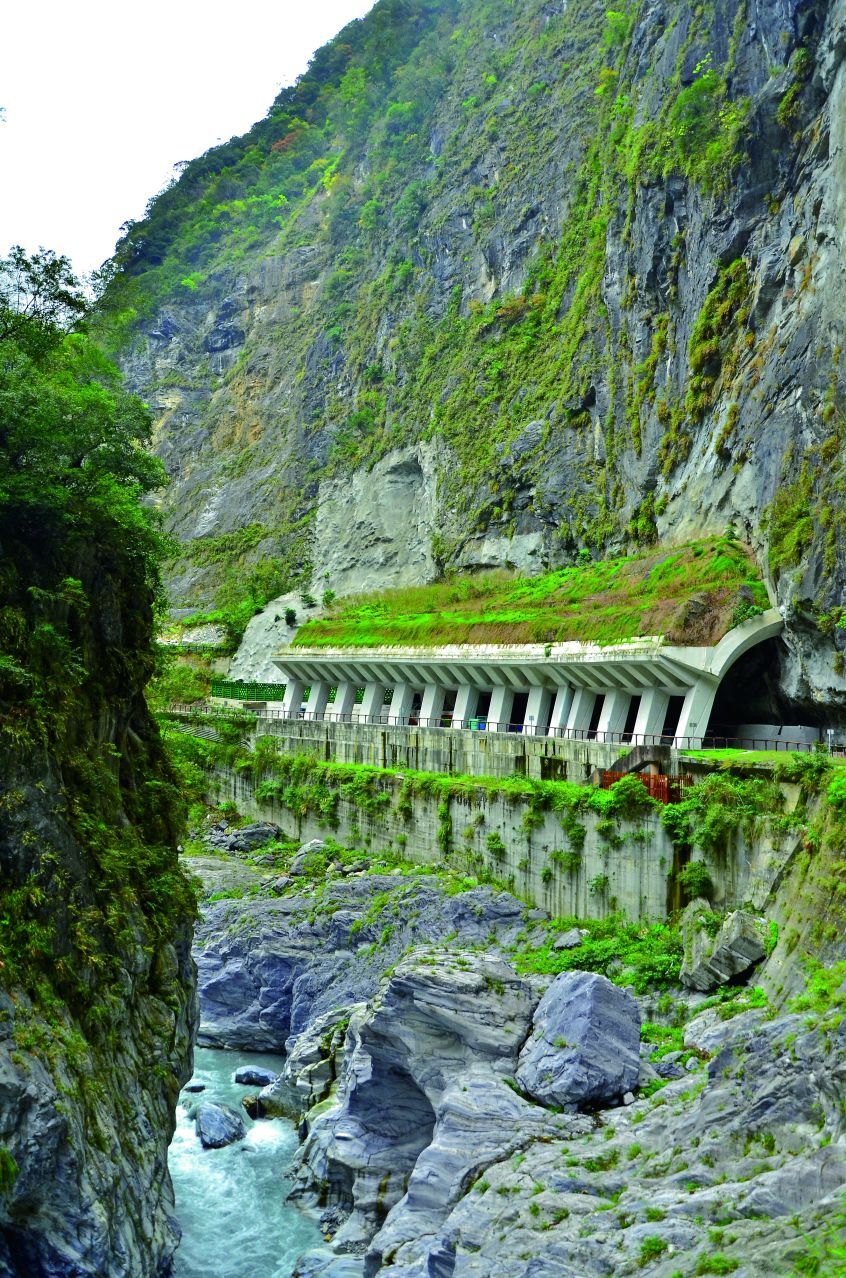
The rock sheds within the gorge serve as vital emergency shelters.

Reconstruction after the 2024 Hualien earthquake

加天空.jpg)


