
A Summer Getaway to Historic Trails in National Parks-
With the pleasant sun coming out, you might be tempted to walk oudiv>
The historic trails that scatter throughout Taiwan have very different fates. Some of them have been fortunate enough to be designated into national parks or government agencies, and were able to retain their original looks thanks to the care and maintenance dedicated to them. Due to limited space, in this issue of NPQ, we will feature one historic trail from each of Taiwan's national parks, and we sincerely invite our readers to plan for a walk down the historic trails on a beautiful summer day and see what they have to offer.
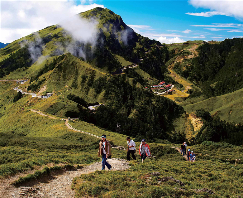
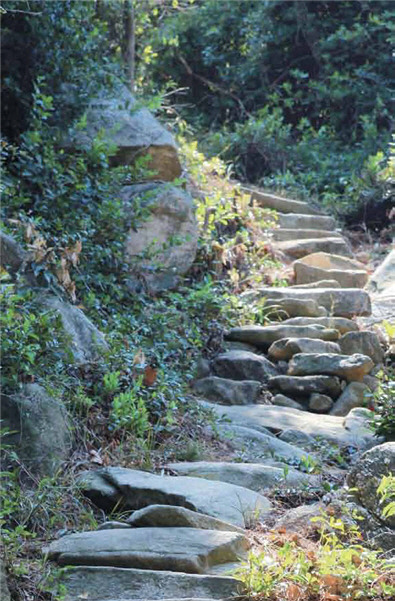
Langqiao Beinan Historic Trail in Kenting National Park (KTNP)
Length of the trail: Approx. 12 km.Park entry permit: Not required but visitors are advised to follow a guide familiar with the route.
Best season for visit: Spring, fall and winter.
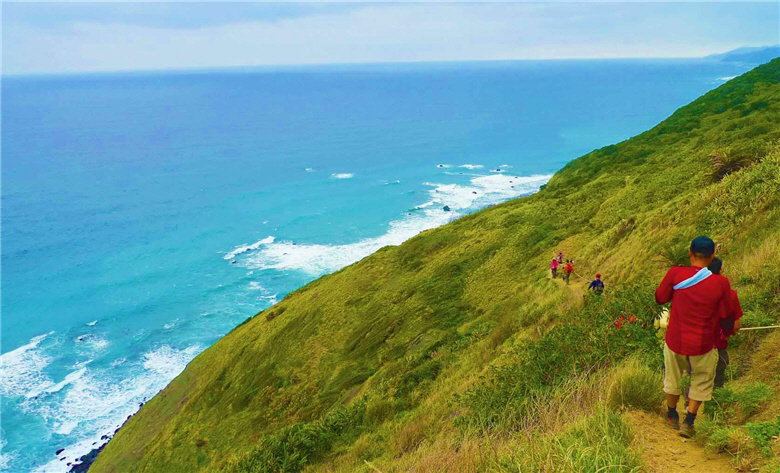
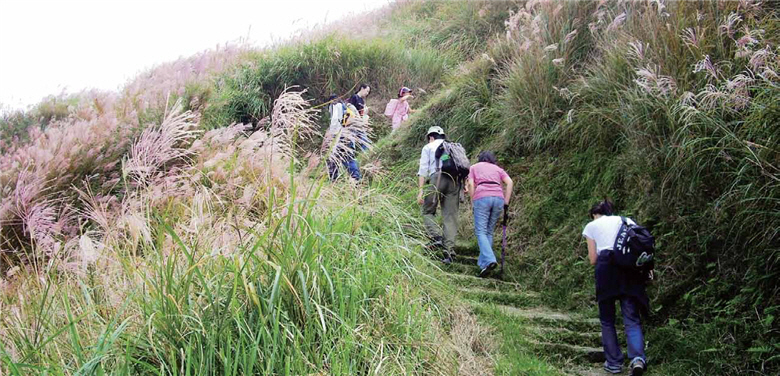
Alangyi Historic Trail, the last part of Langqiao Beinan Historic Trail in KTNP, is the only gap in Taiwan's round-the-island highway network. The place is not easily accessible, and hence won the titles such as "the corner of the world," "the pure land,"etc. Nonetheless, Alangyi Historic Trail is still known for its breathtaking scenery, rich ecological resources, and abundant cultural heritages. A walk down the vestige of this ancient trail will take you back in time and make the entire trip absolutely worthwhile.
The north-south Langqiao Beinan Historic Trail dates back over 5,000 years. But the first recorded use of the trail was in the Dutch rule, during which the indigenous people depended on the road to hunt,form alliances and migrate to eastern Taiwan. In the wake of the Mutan Incident in 1874, the trail rose as a major main street for the government officials and the Han people, but its importance declined as the Qing government switched its focus to north Taiwan. The part of Alangyi Historic Trail that still exists as of today stretches between Hsuhai Village and Nantien Village, with a total length of approx. 12 km.
- upper:A visit to the historic trails, where the ancestors had once trodden, can be a feast of the natural beauty of Taiwan witnessed by the history. /by Shi-jie Lian
- lower:Alangyi Historic Trail is the only gap in Taiwan's round-the-island highway network./ by Wan-ching Lai
Compilation & Text / Jun-pei Xia
Special Thanks to / Ms. Cyong-yao Lin of KTNP Headquarters
Ms. Chien-wen Gao 、Mr. Chang-zhi Chen of KMNP Headquarters
Mr.Mao-yao Lin of TNP Headquarters
Chief Li-chang Lu、Technical Specialist Ms.Shu-chun Yu of YMSNP Headquarters
Ms. Hui-fang Liu of SPNP Headquarters
Ms. Le-jia Shang of MNP Headquarters
Ms. Wen-ling Tsai of YSNPHeadquarters
Ms. Ying-chan Chen of TJNP Headquarters
Along the trail, Guanyin Bi blocks Hsuhai from Nantien. To travel across requires a quick jump over the rocks when the tide ebbs or a detour climb up from above. It is said that this route used to be called "the hush zone" because people had to, other than run against the tides, stay quiet so as to shun the possible attacks by the Paiwan aborigines. The area is also the habitat of coconut crabs (Birgus latro) and green turtles (Chelonia mydas japonica) , and ancient relics such as pottery fragments and slates are also everywhere on the trail to remind people of the ancestors' ways of living.
Japanese Occupation Era Batongguan Traversing Trail in Yushan National Park (YSNP)
Length of the trail: 125 km.Park entry permit: Not required if travelling to Jiasin and back; once over Jiasin, visitors have to go to Nan-an Police Squad for the park entry permit.
Best season for visit: All seasons.
In ancient times, the Tsou People who lived along the Chenyoulan River called their sacred mountain, Yushan, Batongguan. There are two trails that hold the same name of Batongguan: one is Qing Dynasty Batongguan Historic Trail, which is also the only trail in Taiwan designated as a national historic site. The other one is Japanese Occupation Era Batongguan Traversing Trail. Though the two trails are of the same name and both run eastward through Yushan to Hualien, their routes are quite different and only intersect in the Batongguan grassland and Dashueiku areas.
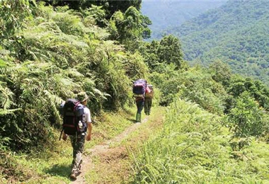
The section from Nan-an to Walami of the Japanese Occupation Era Batongguan Traversing Trail measures about 14 km. Though only 1/10 of the 125-km trail, this section exhibits many attractions worth exploring. Also, the elevation here rises from 460 m to 1,068 m, so the forests may vary from the temperate hickory forest, evergreen broadleaf forest and Alnus forest, to the temperate conifer-broadleaf mixed forest with Formosan Cypress (Chamaecyparis formosensis) and Taiwan Spruce (Picea morrisonicola Hayata).
When departing from the east entrance of the trail, one would pass Shanfong, where a Japanese style ancient bridge built in the 1930s is still there. Moving on, you will reach Jiasin, where Jiasin Station was located during the Japanese rule but now only an observation deck is left, with a pavilion and a restroom. The trail ends in Walami station, a new solar-powered mountain cabin for tourists.
The term “Walami” can be interpreted in a few ways, and one translates it into "ferns" in Bunun language, for the trail is covered by all species of ferns. Be sure to stop for a detailed view of these plants from the Jurassic era.
Jinbaoli Big Road (Fishermen's Trail) in Yangmingshan National Park (YMSNP)
Length of the trail: The section currently open (from Shanzhuhu to Xuyan Bridge) is approx. 4.2 km.Park entry permit: Not required.
Best season for visit: All seasons, except for northeast
monsoon season in winter.
- upper left:The area between Shanfong and Walami is filled with a great variety of pteridophytes./ by Chuang-jhuang Ciou
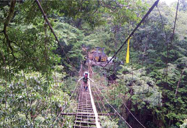
- upper right:Yisila Suspension Bridge, built during the Japanese rule, is located in the west of Yisila Police Station on Japanese Occupation Era Batongguan Traversing Trail./ Provided by YSNP Headquarters
- lower:The name“ Fishermen's Trail” quite lives up to its name. In the old days, the trail was used by the fishermen erto transport fish between Jinshan and Shilin./ Provided by YMSNP Headquarters
The name “Fishermen's Trail” quite matches its use in reality. In the old days, the trail was used to transport fish between Jinshan and Shilin. Back then, the fishermen in Jinshan had to ship their catch via this road to Taipei for sale. Then they could use the money to get some daily supplies and return home. The single trip from Jinshan to Shilin is a long 30 km, showing how difficult it was for the ancestors to make a living then.
In 1858, British naturalist Robert Swinhoe also took this road. It is said that he departed from Jinbaoli at 5 a.m. and arrived at Shilin around 9 p.m.
Fishermen's Trail is a highly sought-after one among Taiwan's many historic trails. This may has to do with the relatively accessible location of Yangmingshan. You can try either the south or the north section (bordered by the gate of Jinbaoli Big Road in Qingtiangang) of the trail or the entire trail. Whichever way is full of the well known attractions such as Qingtiangang,Juansi Waterfall, Lengshuikeng and Xuyan Bridge.
The north section of the trail can be further divided into two parts: the Japanese Road and the Ho-Nan-Braves Military Patrol Trail. The former, planned by the Japanese and partly built by Da-shi Jian during the early Japanese rule era, is more like a flat ramp used for military purposes, whereas the latter is steeper because of its stone steps. Many people would experience both sections during their round trip. But as some parts of the trail are still under maintenance, the section currently open is from Juansi Waterfall to Xuyan Bridge.
Lyushui Trail in Taroko National Park (TNP)
Length of the trail: Approx. 2 km.Park entry permit: Not required.
Best season for visit: All seasons.
- upper:Every inch in the Wantian Battery Relics Trail bears testimony to a mournful history, even though it is not qualified for a historic trail./ by Jia-hong Chen
- lower left:Along Lyushui Trail are scattered with monuments erected by the Japanese./ by Mao-yao Lin
- lower right:Lyushui Trail is shorter, but the 2-km mini trail has it all: a rich and varied assemblage of forests, ecological resources, tunnels, river valleys and cliffs./ by Mao-yao Lin
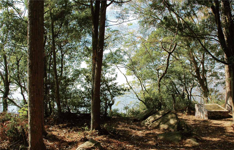
With its entrance located next to the exhibition hall, the trail is characterized by dense forests, cliffs,lithophytes and cultural relics. When stepping on the path covered by gravel and leaves and full of cultural value in such lush green quiet woods, one could still get a feel of the turbulent period in history.
In addition to its cultural features, Lyushui Trail is also a great place for observation of some special plants, such as Quercus tarokoensis, Cyclobalanopsis glauca, Deutzia pulchra , and Camphor trees (Cinnamomum camphora) . The rare Quercus tarokoensis is endemic to Taiwan and is mostly scattered around the marble area at the east section of Taroko. Never miss out on these intriguing species when you pay a visit there!
Wantian Battery Relics Trail in Shei-Pa National Park (SPNP)
Park entry permit: Not required.
Best season for visit: All seasons.
Located in Xuejian Recreation Area in SPNP, Wantian Battery Relics Trail covers from Erbensong Tourist Station to the relics of Wantian Battery. To get there, one can take Simaxian Forest Road. The trail itself is not really long, neither is it qualified for a historic trail, but it bears testimony to a mournful history. In fact, Wantian Battery was set up by the Japanese during the Japanese rule to quell the gallant Atayals. The name was in memory of a Japanese officer named Maruta (or Wantian in Chinese), who died in the Beishih Battle.
- left:The relics of the Hundred and Twenty Stairs Historic Trail in Caicuo Historic Trail./ Provided by KMNP Headquarters; by Zhang-zhi Chen
In fact, the Japanese also found the relics of the ancestors from the prehistoric times dating back to the Old Stone Age. To unlock the mystery of this particular part of history, one may visit Wantian Battery Museum, where artifacts of the Atayals, historical data related to Erbensong and Wantian Battery as well as the brave fight by the Atayals against the Japanese suppression.
Erbensong Tourist Station is at an elevation of 1,320 m and at the 14 km mark on Simaxian Forest Road. There is an observation deck where visitors can overlook the entire valley of Da-an River. Behind the deck is a thick bamboo forest, and through the trail there, you can reach the relics of Wantian Battery. With the Cunninghamia lanceolata, Cunninghamia konishii Hayata, Alocasia macrorrhiza, Ardisia cornudentata Mez, your trip will always prove rewarding. But also be on the lookout for the Stinging Nettle (Urtica thunbergiana) to avoid skin irritation.
One hundred meters m from the relics stand the trig points set up in the past and the present. At the relics, still there on the platform is the monument, along with a few ruined trees, which usually arouse people's emotion about the vicissitudes of life.
Caicuo Historic Trail in Kinmen National Park (KMNP)
Length of the trail: Approx. 2-3 hours of walk.Park entry permit: Not required.
Best season for visit: All seasons, especially in spring. Care must be taken in the areas around the ridges where rain or gusts can get really bad sometimes. Visitors are advised to come in groups or with experienced climbers. A complete trip requires more time, and please start the hiking no later than in
the evening.
Caicuo Historic Trail in the KMNP lies on the north of Taiwu Mountain, at the foot of which the Caicuo ancestors used to gather and settle. The trail is the the ancient footway through which residents in Caicuo reached the Haiin Temple. In 2006, a hiker found a stone tablet at Caicuo Historic Trail that can be traced back to the Yuan Dynasty in 1363. The discovery of this "Stone Tablet of Yuan" shows that human activities already took place on this trail way back in 600 years ago.
Further down the trail is the Yuanlu Lake, a natural pond that was transformed into a man-made lake by KMNP in 2010 in order to Conserve water. Continue forward and you'll get to ridge, where the scenery is beyond compare, and you can feast your eyes on the Houjiang Bay. Then the road branches off, with one leading to the Stone Tablet of Yuan and the Haiin Temple and the other passing military strongholds such as Dabao and Xiaozhubao. You can also enjoy the islet's grand northern coastlines.
- upper:After the establishment of Dongsha Atoll National Park, more and more historical data on the ocean has been collected./ by Shu-kuo Hsu
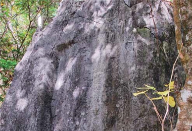
Moreover, as Kinmen is mainly made up of granite, granites in peculiar shapes are all over the place and along the trail, presenting a perfect combination of grandeur and roughness.
A wide variety of plants can be found in Caicuo Historic Trail: Pyrus calleryana Decne,Rhododendron simsii Planch, Spiraea blumei G. Don, Litsea glutinosa (Lour.) C. B. Rob and Rhaphiolepis indica Lindl. var. Tashiroi Hay. bloom in different seasons, keeping you enthralled all the way and making your visit to the trail particularly memorable.
Historic Traces on the Sea in Dongsha Atoll National Park
For quite some time, much research attention has been placed on the Taiwan proper, and far less on the seas and oceans around it, as well as their relations with Taiwan. But the situation changed for the better when Taiwan saw its first marine national park, Dongsha Atoll National Park. Though the park hasn’t been open to the public, more historical data on the ocean has been collected, offering those who are interested in maritime history a platform to learn and to connect.
Dongsha Atoll National Park, covering an area of a radius of 12 nautical miles, is the only place with a well-developed atoll. Generally speaking, tens of millions of years is what it takes for coral islands to develop into an atoll, making them both extremely precious and vulnerable. The location of Dongsha Island in the northern tip of the South China Sea means that ships from Macau and Fujian to the Luzon could hardly miss the beautiful “atollon” (the original name of atoll).
In addition to its strategic location, several ancient shipwrecks have also been found here. These findings can prove useful in the research into the life and the commercial activities of the people in the past, and the relative location of the shipwrecks can be used to look into the characteristics of the waters. As a result, archaeologists around the world now regard the island as a major archaeological site for marine cultures and history.
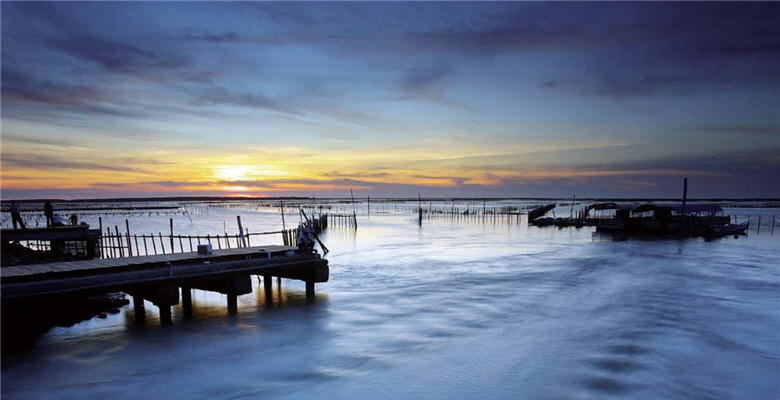
Zhufagang River in Taijiang National Park (TJNP)
Distinct from most historic trails in other national parks, the ones in TJNP feature Taiwan’s first canal, and the sea route taken by the ancestors for migration from Xiamen in mainland China to Luermen in Taiwan. Both trails on the water serve as memories to remind people of their predecessors'lifestyle and hardship.
In the reign of Qing emperor Daoguang, Taijiang was often silted up due to the flooding Tsengwen River. So the then three chambers of commerce in Tainan dug Zhufagang River for the transportation of daily necessities such as salt, sugar and crops.This south-north 12.3-km canal extends from Sihcao Lake to Guosai Harbor, and allows only rafts to sail through, hence getting its name “Zhufagang” (raft harbor). Bigger boats had to be moored in Guosai Harbor, and materials onboard transported to rafts, which then proceeds to the city. The canal has long been abandoned, with its north section used as a drainage channel and the south section submerging into the water.
TJNP also covers the area within 20 m of the submarine contour line, and a 5-km-wide, 54-km-long sea area from Yanshuei River estuary to the southern tip of Tongji Island. These areas saw many major developments, and left traces of some representative routes for historic events such as the landing of Koxinga to Taiwan and the Chinese mainlanders’ migrations to Taiwan during Qing Dynasty. These are well worth a visit as essential symbols in Taiwan’s history.
- upper:Taijiang National Park boasts age-old historic sea routes. / by Shi-zhan Qiu
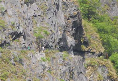
Meaning behind the Naming of the TrailThe trail got its name because it crosses over Jhuilu Cliff and is part of Old Cross-Hehuan Mountain Road. It was built during the Japanese rule as the roads for aborigine pacification and for hiking purposes. Length of the Trail10.3 km Location in the National ParkFrom Yanzihkou to Cihmu Bridge Current State of the TrailIt is designated as a historical preserved area in TNP with access open to visitors but Park Entry Permit and Mountain Permit required. Number of visitors allowed is 48 per day during the weekdays and 72 per day over the weekend and holidays. Best Season for VisitAll seasons Name of the Historic TrailLyushui Trail Meaning behind the Naming of the TrailPart of Old Cross-Hehuan Mountain Road, the trail was built during the Japanese rule as the roads for aborigine administration and for hiking purposes.
After TNP was established, it was renovated into a scenic trail. Length of the Trail2 km Location in the National ParkFrom Lyushui to Holiu Current State of the TrailNo permit is needed and access is open to all visitors. Best Season for VisitAll seasons Name of the Historic TrailShakadang Trail Meaning behind the Naming of the TrailThe trail was built during the Japanese rule (in 1940) for the construction of the Liwu Power Station. After the establishment of TNP, it was renovated into a scenic trail. Length of the Trail4.4 km Location in the National ParkFrom Shakadang Bridge to Sanjianwu Current State of the TrailNo permit is needed and access is open to all visitors. Best Season for VisitAll seasons Name of the Historic TrailShihkungtzu Trail (Northern Road Meaning behind the Naming of the TrailFollowing the Mutan Incident in Qing Dynasty in 1874, the trail was built as the "Northern Road" for trailblazing and aborigine pacification. The trail starts from Su-ao to Hualien and crosses Qingshui Cliff. Most sections of the trail have been damaged, and Shihkungtzu Trail is part of the Road. Length of the Trail- Location in the National ParkFrom the south end of Chongde Tunnel of Su-hua Highway to the north end of the Huide Tunnel. Current State of the Trail- Best Season for VisitNot open yet
Meaning behind the Naming of the TrailIn ancient times, the Tsou People who lived in the valley at the upper reach of Jhuoshuei River called their sacred
mountain, Yushan, Batongguan. In Qing Dynasty, when Wu Guang-liang built the road, he mistakenly marked the name of the place with a wrong Chinese character as Ba”tung”guan at the upper reach of Laonong River. Later in the 1888 version of the map of Taiwan’s aboriginal areas, the correct name was adopted and has been used as of today. Length of the Trail153 km Location in the National ParkFrom Jhushan, Nantou County through Central Mountains to Yuli, Hualien County. Current State of the TrailThe trail is open to the public under certain conditions. For detailed information, visit the official website at http://www.ysnp.gov.tw. Best Season for VisitAll seasons Name of the Historic TrailJapanese Occupation Era Batongguan Meaning behind the Naming of the TrailDespite the same name of Batongguan Historic Trail, the one built during Japanese rule and the other in Qing Dynasty were totally different in terms of their routes. They only overlapped at Batongguan and Dashueiku. Length of the Trail125 km Location in the National ParkEas tward through Cent ralMountains to Yuli, HualienCounty. Current State of the TrailThe only section open to the public is from Nan-an to Walami in the east of YSNP, and the total length is about 14 km. The section beyond Walami is open to the public contionally. Best Season for VisitAll seasons Name of the Historic TrailGuanshan Traversing Historic Trail Meaning behind the Naming of the TrailSome say the main line of Guanshan Traversing Historic Trail is located along the ridge of the main peak of Guan
Mountain (Guanshan). It is the longest historic trail in Taiwan, originally for the purpose of pacifying the Bunun Tribe living around Xinwulu River in Taitung. Length of the Trail171.06 km Location in the National ParkAt the southwest of the park, from Liu-guei, Kaohsiung, in the west to Li-long, Taitung in the east. Current State of the TrailWhen the Southern Cross-Island Highway was opened in 1972, most part of the Guanshan Traversing Historic Trail was linked together. The section around Jhongjhihguan has been the better preserved part of the trail. But the roads leading to it were damaged, so the trail is not open for the time being. Best Season for VisitNot open yet
Meaning behind the Naming of the TrailThe trail has long been an important passageway used by the aborigines (including Paiwan, Beinan, and Amis Tribes) to and from the plains of southwest Taiwan, Hengchun Peninsula, and eastern Taiwan (mainly Taitung and Hualien Counties). It was originally used for hunting, trade, intermarriage, alliance and migration. In the wake of the Mutan Incident in 1874, when the Japanese invaded Taiwan, the trail, under Qing government's effort, rose during 1877 to 1885 as the only and most important main street for the government officials, troops and the Han people to eastern Taiwan. Length of the Trail203 km Location in the National ParkNortheastof KTNP , from Manjhou to Jiupeng (currently Pintung County Highway No. 200). It starts at Hengchun, goes through Manjhou, following the coastline and through Bayaowan and Mutanwan before heading north to Daren and Beinan. Current State of the TrailMost of the trail has turned into a highway for vehicles. A 4-km coastline section from Hsuhai Seaport to Mutan Bi and Guanyin Bi to Tawa River at the border of Taitung County, is the only part where some trail remnants and the trail’s pristine look have been preserved. (Note: Alangyi was the old name for Anshou Village, and Alangyi Historic Trail generally refers to the section from Hengchun Peninsula to Anshou Village.) Best Season for VisitOct. to Apr. (Fall, winter and spring)
Park
include the Juansi Waterfall to the Shanghuangsi Parking Lot, and Bayan to Tienlai. Best Season for VisitAll seasons, except for northeast monsoon season in winter.


