
Embraced by Mountains-Walking the Trails of Tataka Recreation Area

Overlooking the Nantzuhsienchi river valley and Guanshan Mountain in the distance. / Hsiao-Lu Ho
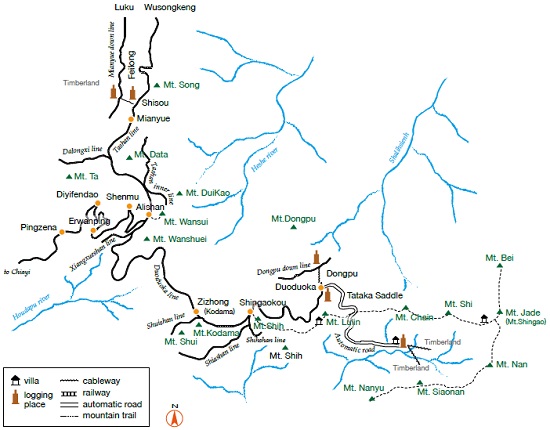
The 15-mile hiking trail map of Tataka recreation area. / Source: Yushan National Park Headquarters, re-illustrated by Chien-Wang Wu
Interviewee / Li-Min Yin, Tataka Station, Yushan National Park Headquarters Article / Hui-Ying Lui Photo / Li-Min Yin, Hasio-Lu Ho
Tataka Recreation Area is very easy to access. It contains many hiking trails connecting Linjhih Mountain, Dongpu Mountain, and Lulin Mountain, creating a network weaving through the sceneries of Tataka area, making it one of the most valuable hiking areas among mountaineering enthusiasts. Li-Min Yin told us, Professor Ying Wang (School of Life Science, National Taiwan Normal University) who has traveled all over Taiwan and is familiar with all the important ecological areas, once praised Tataka, “When it comes to the visibility of wildlife in such approachable recreation area, this place is only second to Fushan Botanical Garden”. However, you don’t need to apply for a permit to visit Tataka. Yushan National Park is open to everyone. As long as you desire, you can come here to be close to nature at any time! So what is it about Tataka that is so charming? Professor Wang’s words made us even more curious!

The picture that Fuci Tree (couple tree) once accompanied / Hsiao-Lu Ho

Fuci Tree (couple tree) has always been a famous landmark of Tataka. The husband tree on the right has been defeated by the times and fallen down. / Yushan National Park Headquarters
Easy Access and Suitable for all Ages
“Our people are very fortunate that the mountains are so close to us. From Nantou County Shuili Township which is about 243 meters above sea level to Yushan’s Tataka which is about 2,600 meters above sea level, it takes only about 1.5 hours to drive from the plains to the mountains.” Even if you drive up from Chiayi passing through the internationally renowned Alishan area, it still only takes about 150 minutes by car to Tataka. Tai-18th Highway (New Central Cross-island Highway Chiayi-Yushan Line) starts from the Chiayi High-speed Railway Station in Taibao City, Chiayi County then connects to Tai- 21st Highway after a meandering 108.559 kilometers and ends at the Tataka Visitor Center. Tai- 21st Highway begins at Tienleng of Dongshi Area in Taichung City with a total length of 144.3 kilometers. It also ends at the Tataka Visitor Center. Among them, the Nantou Shuili to Tataka section is called the “New Central Cross-island Highway Shuili-Yushan Line”.
In addition to easy access, the trail system at Tataka Recreation Area covers a wide variety of difficulties, ranging from woodland pathways for all ages to challenging and fascinating hiking routes. People always think mountain views from 2,500 meters above sea level is so out of reach, but Tataka, which is located at the northwestern corner of Yushan National Park, is a very approachable mountain region with smooth roads that can be reached by vehicles anytime where everyone can enjoy and re lax. Tai-21st Highway begins entering Yushan National Park at the 119km mark. It passes by Tataka Visitor Center and extends all the way to Shishan Service Station (Tai-18th Highway 103.9km). Thi s a lpine sceni c highway has a total length of about 30 kilometers with pit stops at Guanfeng, Guanshan, and Fuci Tree along the way. Besides overlooking the majestic ridge of Taiwan – the Yushan Mountains, and enjoying the seasons of the mountains, when the sky is painted with rosy glow during sunrise and sunset, one can truly feel how small people are against the magnificent mountain scenery.
The totall ength of the trail system at Tataka Recreation Area is approximately 15km. Linjhih Mountain Trail, Lulin Mountain Trail, Lulin Front Mountain Trail, and Dongpu Mountain Trail all have different difficulty levels. However, most of the paths and trails are connected to each other forming a web of trail routes and can satisfy the different needs of most people’s hiking plans. Lulin Front Mountain has an elevation of 2,862 meters, Linjhih Mountain is at 2,854 meters, Lulin Mountain at 2,845 meters, and Dongpu Mountain at 2,782 meters; people who like to challenge their physical abilities can attempt to climb all of them in one day. For those who enjoy a slower and easier pace, a two-day one-night trip or three-day twonight trip will be more appropriate. “Spend a night at Dongpu Villa Hostel, have plenty of time to fully experience the ecological beauty of Tataka during the day and night. Visitors who come to Tataka for the first time can get a lot of vital information from the visitor center, but more importantly, is to go out and experience the different faces of nature of every moment.”
Li-Min Yin felt that the ease of access to Tataka also caused visitors to just come and go in haste. “It is a pity for folks to just come for a fleeting visit. We can give peoplegood trip suggestions. People only have to make a detailed plan before the trip, then call the visitor center to confirm weather or traffic information.” For Li-Min Yin who has been doing “dusk investigation” at Tataka rain or shine for more than eight years, there are too many things she can share, she’s more afraid that people don’t ask.
Alishan Forest Railway Map during the Japanese occupation period. / Source: “Legend of Taiwan Railway”, re-illustrated by Chien-Wang Wu

Datieshan (Gigantic Hemlock) is Tataka’s spiritual landmark and is also where Yushan Forest Road and Nantzuhsienchi Forest Road intersect. / Hsiao-Lu Ho
Traces of History
“Tataka is famous for its natural ecology, but few people know that there are many interesting historical traces. Do you know that the Alishan Forest Railway was once extended all the way to Tataka during the Japanese occupation period? This branch line was called the “Duoduoka line” and was mainly used to develop forest resources in the greater Alishan area (including Yushan)”. At that time, two routes branched out from the Alishan Station were the two main lines of the Forest Railway, one north to Mianyue and one south to Zizhong (originally called Kodama, commemorating the 4th Governor Kodama Gentaro during the Japanese occupation period) and Shingaokou. Three more branch lines were then split out from Shingaokou: Shiashan line, Shihshan line, and Duoduoka line (also known as Dongpu line).
Duoduoka line continued to operate till the end of the Alishan and Yushan logging industry and was dismantled around 1977. At that time, the water station on the Shingaokou to Dongpu Mountain Duoduoka line was located at Shishan, which was known as the highest railway station in Taiwan. Now we can only recollect the scene of small trains entering the station from stories narrated from elderlies over seventy years old and the names of the places. After the Zizhong to Shingaokou line were demolished, its railway bed was reconstructed into the New Central Cross-island Highway. Maybe someday when driving on this stretch of highway, travelers who have read about this history can imagine a small train steaming and whistling, running alongside with them.
Meandering Forest Roads
In addition to the forest railway, forest roads that vehicles can drive on and carry giant tree logs down the mountain were also built at the Tataka area from the Japanese occupation period to the National Government’s arrival in Taiwan. These forest roads are Shenmu Forest Road, Yushan Forest Road, Nantzuhsienchi Forest Road, and Shalihsienhsi Forest Road.
Shenmu Forest Road, with a total length of 12.7 kilometers, starts at Shenmu Village, Xinyi Township in Nantou County at 1,276 meters above sea level, and ends at what is currently the Tataka vehicle parking lot with an elevation of 2,581 meters. Shalihsienhsi Forest Road starts at Tataka Saddle heading toward Dongpu, which is one of the passageways for climbing Yushan in the past. However, an unstable land condition caused by the 921 Earthquake and the continuous raids of windstorms in successive years triggered severe landslides, resulting in the Shenmu Forest Road and Shalihsienhsi Forest Road are no longer fully accessible. Due to the larg e scope of the landslide, there is no comprehensive restoration plan so far.
Yushan Forest Road and Nantzuhsienchi Forest Road intersect at Tataka’s famous landmark “Datieshan (Gigantic Hemlock)”. When Yushan Forest Road was established in 1967, it was mainly used as a replacement logging route for the forest railway. It starts from Shingaokou passing the south foot of Shishan Mountain, crossing Shishan Mountain and Lul in Front Mountain Saddle and then circle Lul in Front Mountain and the north foot of Lulin Mountain, finally arriving at Datieshan and connects to Nantzuhsienchi Forest Road from here. Its total length is about 8 kilometers, but currently, it is only opened from Datieshan to Lulin Front Mountain trailhead, about 2.4 kilometers. The starting point of Nantzuhsienchi Forest Road is at the upper Dongpu parking lot and used to end at Meilan Saddle in the past with a total length of nearly 35 kilometers. Due to damage caused by typhoons and earthquakes, it is currently only opened to Nanchi Service Station, where vehicles can only pass for about 10 kilometers. However, only automobiles for research and official duties are allowed to enter, no other vehicles (including bicycles) are allowed in.
Much to Consider when Restoring Forest Roads
In addition to visible costs such as man-hours and materials when restoring forest roads, more importantly, they often pass through geologically or ecologically sensitive areas. Therefore, it is necessary to comprehensively assess the disturbances the restoration would cause to the environment and the ecology.

Shingao trailhead monument (Dingkan Village, Shuili Township, Nantou County) / Hsin-Yao Hsiao

Spectacular sunrise can be seen at the Tataka Tai-21st Highway. / Hsiao-Lu Ho
The Time when Climbing Yushan was a Challenging Task
Railway, Forest Road and Highway, even though many old routes no longer exists, from the current point of view, it still seems that every road leads to Tataka. One only have to hike 10.9 kilometers from the Tataka trailhead and the main peak of Yushan will be right there in front of you. But Li-Min Yin simply said, “Climbing Yushan was not so easy in the past!” and took us back to the time when these traffic infrastructures have yet to be completed.
In the early days of the Japanese occupation period, there were three routes to climb Yushan (then known as Shingao Mountain). One of them was from Alishan Zhaoping Station following the ridges of Shuishan, Shishan, and Lulin Mountain, walking all the way to Tataka Saddle, then begin the climb up Yushan. It was a very long and time-consuming journey. Famous Japanese scholars Torii Ryuzo and Mori Ushinosuke both used this route to climb Yushan. Unfortunately, after the highway has reached Tataka, this ancient trail has gradually deteriorated, and its trace has become unclear. The second route is from Hualien Yuli heading up to Batongguan Crossing Trail and then turn into Yushan mountain trail (Shingao mountain trail) to head up Yushan. The third route is to start from Nantou Shuili, the trailhead is located at today’s Dingkan Village, which is the starting point of Tai-16th Highway and Tai-21st Highway. The Shingao trailhead monument established in 1937 (Showa 12) is still intact today, standing keeping a low profile among the city streets. It would take about 5 days for either route to reach the Tataka Saddle. It was not an easy task to conquer Yushan. No wonder those naturalists who first enter Yushan are highly praised by later generations not only for their academic achievements in collecting and documenting, but also for their spirit and perseverance for taking risks to explore the mountains.

Tataka is easily accessible, and thescenery along the road is very fascinating./ Hsiao-Lu Ho

Yushan Rhododendron blossom is the phenological focus of Tataka from the end of March to the beginning of April. / Li-Min Yin
Surrounded by Mountains with Beautiful 360-Degree Sceneries
If you are on the peak of Lulin Mountain or Linjhih Mountain on a clear day, you can overlook Alishan mountain range and Nantzuhsienchi river valley on the west, and even see Guanshan Mountain in the distance on the south. If visitors want to see sunrise or sunset, they can consider following the “sunrise Dongpu Mountain, sunset Linjhih Mountain” rule, which is the best lookout places because of their geographical location and mountain form. Lulin Mountain is a great place for visitors to watch cloud seas, cloud falls, sunsets and stars. This kind of scenery is definitely worth arranging an additional twoday trip for everyone to stay at Tataka. When we look at Linjhih Mountain, we can see that the north face of the mountain is a complete natural forest, while the south face (Except the Black Forest) is in the primary succession vegetation stage after a fire. “This situation will make people think. Fire is ruthless. It is only a matter of seconds to ignite a forest fire, but it will take nature centuries or longer to recover.” Therefore, one should cherish the life of the forest, moreover, carefully manage our own behavior.

Tataka is painted red by Taiwan Red Maple during autumn. / Hsiao-Lu Ho

A Formosan Sambar family foraging on the hill. / Li-Min Yin
Life is Everywhere, Awaiting People with Good Intentions
In addition to the spectacular mountains and rivers, the seasonal phenology of Tataka is even more charming. Generally speaking, from the end of March to the beginning of April is the blooming season of Yushan Rhododendron. You only need to be on the trail or the forest road looking toward the nearby hillsides, and you will have a great chance to see fields of blossoms. It is the alpine annual’s turn to put on a show from May to November, then Taiwan Red Mapl e and Taiwan Stranvaesia would paint the mountains red in fall.
Specific seasonal animal migration or gathering scenery is also not to be missed! You can see clusters of purple crow butterflies dancing in the Shalihsienhsi river valley from mid to late June. In addition, summer is the prime time to watch alpine butterflies. However, the best viewing time is usually before one o’clock in the afternoon, because it will be difficult to see these little fairies flying after the fog comes in or the temperature drops. Chinese Goshawk and Gray-faced Buzzard will pass through Taiwan in September and October. If you look north from the Linjhih Mountain top (Zichung is also a good place to watch eagles) around six to twelve o’clock in the morning during those months, groups of eagles can be spotted flying from the direction of Xinyi Township heading south passing through Tataka. A few years ago, Professor Chao-Chieh Chen’s research team from Kaohsiung Medical University found that during the migrating period, the number of eagles seen at Tataka is about half of the numbers traveling out towards the sea from Kenting the next day. This is one of the few wonderful eagle watching spots in Taiwan that do not require to stand under the scorching sun.
Tataka is a word from the Tsou Aboriginal language, which means wide-open and flat grassland; in Bunun language is Kan-sia-sia-han, which means slippery foot marks of sambar. “But it is very hard for everyone to believe in the early stage of Yushan National Park’s establishment, not only sambar, even Formosan macaques are rare in the Tataka area.” This is because Tataka used to be a planned economic logging region, plus later the development of the New Central Cross-Island Highway have caused a lot of disturbance to the natural ecology. However, under the factors of the conservation policy of Yushan National Park and the awareness of environmental protection among people over the past decade or so, the local ecology has gradually recovered. Results from Li-Min Yin’s evening surveys are the best testimony. Being at the top of Taiwan’s ecological pyramid, Formosan black bear was recorded at the Nantzuhsienchi conservation research station and the Lulin Mountain area in recent years. Li-Min Yin also excitedly shared her story about her encounter with the huge Formosan Sambar on the trail from Linjhih Mountain to Tataka Saddle.
When asked what to do when encountering wild animals on the trail, Li-Min Yin jokingly said, “It is not so easy to cross path with Formosan black bears”, but Reeves's Muntjac and Mikado Pheasant are regulars on the morning and evening walks. “If it is a group of people hiking together, the person who first spotted the animals must stay calm and stop, move as little as possible and keep quiet, so that the people at the back of the pack could have a chance to observe these wild animals.” The wild animals in Tataka have generally become accustomed to people’s presence, but they must be approached and observed in a correct way to maintain this long-established “understanding” or reaction. No disturbing and no feeding is the most basic attitude. If we can learn more about their ecology and habitual behavior before the trip, not only can we increase the chances of seeing them, but also gain more fun and knowledge to ourselves when visiting national parks.

Mikado Pheasant is most active under the woods during hours of dim light. / Hsiao-Lu Ho

Reeves's Muntjac is a wild animal that is often seen in the Tataka region. Because they are very shy, when cross path with them, do not make too much movement or noise for a chance to better observe them. / Hsiao-Lu Ho
Looking after Tataka Together
“This year, Yushan National Park entrusted Dr. Po-Jen Chiang to conduct an investigation and monitoring system for the habitual behavior of the Formosan yellowthroated mar ten. During the initial capture planning phase, the researcher was specially requested to enhance the possibility of identifying the Formosan yellow-throated martens in the wild. Therefore, after capturing, the ties used to fix the radio transmitters on “Xiaojia” and “Ata” (the names of the two male Formosan yellow-throated martens being traced) were in bright colors (Azure - Xiaojia, Red - Ata) to distinguish the individuals. Because the visibilit y of the Formosan yellow-throated martens in the Tataka recreation area has increased significantly in recent years, they usually operate during the day and are not afraid of tourists. They will run on the trails and forest roads. If the individual can be easily identified, the field staff or visitors will all have the opportunity to all take part in the ‘participatory survey’.” Many of the world’s scientific research fields have incorporated the “citizen science” approach. Li-Min Yin also hopes that people who come to Tataka can discover Tataka through relaxed and interesting participation and observation, and have a deeper connection with this place.
Next time when you come to Tataka, if you happen to run into the lively and adventurous, smart and agile Formosan yellow-throated martens, do remember to see if they are wearing an exclusive “necklace” around their necks. If so, please remember to inform the Tataka staffs when and where you have spotted them, and whether it is Xiaojia or Ata you’ve met.
“The mountains and rivers are always there, but their faces change with the seasons, the day, and the weather.” No one can guarantee what specific beautiful scenery you will find or feel on your every visit, just like the sun rises from the east every day, but whether you can see the sunrise or the magnificent sea of clouds, it all depends on how Mother Nature feels that day. Nature changes rapidly; no single moment will completely repeat the previous moment, therefore, “It always greets everyone with a fresh face”. Why don’t we learn to hold the mentality of every day is a good day, every moment is a good moment, cherish every instant in nature, and follow the animals that live in the mountains and roam around Tataka.

Bright colored radio transmitters were tied to the Formosan yellow-throated martens then released back to the wild. On the left is Xiaojia and on the right is Ata. / Li-Min Yin

Bright colored radio transmitters were tied to the Formosan yellow-throated martens then released back to the wild. On the left is Xiaojia and on the right is Ata. / Li-Min Yin
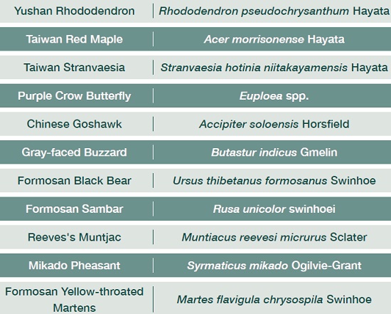
BIOLOGICAL NAME COMPARISON TABLE


